Archäologie
Underwater Archaeological Park of Angra Bay
Underwater Archaeological Park of Angra Bay, on Terceira Island, Azores: shipwrecks from the India Route and the Anchors Cemetery, accessible by diving.
- Lage
- Angra do Heroísmo, Açores
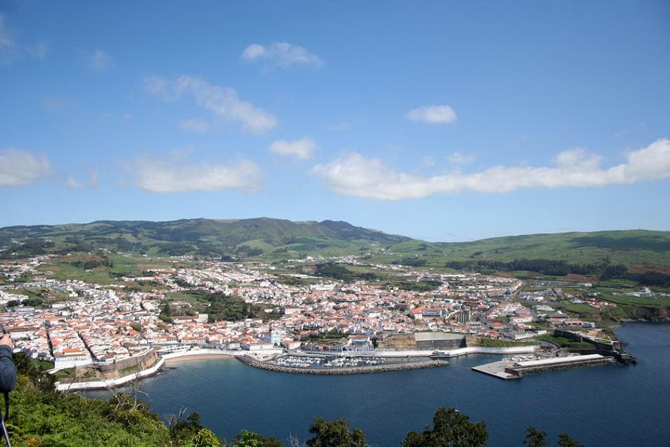
The Underwater Archaeological Park of Angra Bay occupies the seabed of the bay that opens to the south of the city of Angra do Heroísmo, on Terceira Island. Opened to the public in 2006, it is the first park of its kind in Portugal: an underwater museum where the remains of Atlantic navigation lie exactly where they sank, accessible to divers in just a few meters of water.
A harbor of refuge and shipwrecks
Since the 15th century, Angra Bay served as a mandatory stopover for the fleets of the India Route and Brazil routes, sheltering ships laden with gold, silver, porcelain, and spices before their final leg to Europe. Protected from the prevailing north and northeast winds by the volcanic cone of Monte Brasil, the bay was, however, vulnerable to storms from the south and southwest, which over the centuries turned it into a graveyard for ships.
Records document the remains of around 90 shipwrecks since 1552, making the bay one of the places in the world with the highest concentration of shipwrecks from the Age of Discovery. Among the most dramatic episodes is the 1663 storm, which reportedly destroyed eleven ships from the Brazil fleet in a single tempest. Many of these ships remain undiscovered, and about twenty sites have already been identified as archaeologically significant.
Few places encapsulate Angra’s dual nature as well as this: the harbor that enriched Atlantic navigation is also the underwater archive of its losses.
Visitabale sites
Within the park, two areas have been designated for underwater tourism. The first corresponds to the wreck of the Lidador, a passenger and cargo steamship that sank in 1878; its remains lie at a depth of about seven meters and a short distance from the coast, making them accessible even to beginner divers.
The second is the Anchors Cemetery, which stretches along the eastern slope of Monte Brasil, between the Fort of São Benedito and the lighthouse area, for about five hundred meters. There lie dozens of anchors of various types and periods, some over three meters long, abandoned or lost by ships anchored since the 16th century. The collection vividly illustrates the intensity of maritime traffic the bay once witnessed.
Research and protection
Scientific recognition of the bay led to the PIAS project, launched in 2006, dedicated to the study, monitoring, and valorization of the sites. The area aligns with the safeguarding of the historic center of Angra do Heroísmo, classified by UNESCO as a World Heritage Site, extending underwater the city’s strategic importance as a hub between Europe, Africa, and Asia.
Framed within the principles of nautical and underwater archaeology, the park represents an in-situ conservation model: instead of removing the remains to a land-based museum, they are preserved in their original context, combining research with public enjoyment. For visitors to the Azores, it offers one of the archipelago’s most unique experiences and one of the most significant examples of Portuguese archaeology dedicated to submerged cultural heritage.
Häufige Fragen
- Where is the Underwater Archaeological Park of Angra Bay located?
- It is situated at the bottom of Angra do Heroísmo Bay, on the southern coast of Terceira Island, Azores, near the eastern slope of Monte Brasil.
- Is it possible to visit the park?
- Yes. Since 2006, two designated sites—the steamship Lidador and the Anchors Cemetery—have been open to accompanied recreational diving at shallow depths.
- How many shipwrecks are there in Angra Bay?
- Remains of around 90 shipwrecks since 1552 have been documented, of which about twenty sites have been archaeologically identified.