Monuments
Pillories of Tâmega, Sousa and Douro
Pillories of Lousada, Marco de Canaveses, Penafiel and Murça: National Monuments in Tâmega, Sousa and Douro, with their history, dating questions and status.
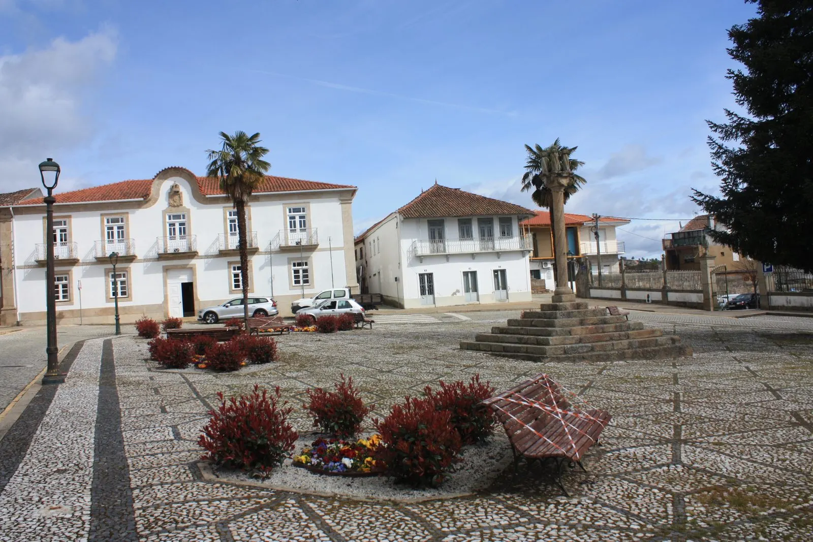
Four pillories in the North, three in the district of Porto, in the Tâmega e Sousa area, and one in the district of Vila Real, are National Monuments: those of Lousada, Marco de Canaveses, Penafiel and Murça. All were classified by decree of 16 June 1910 (Diário do Governo no. 136, of 23 June 1910). The function of the typology, the role of the Manueline foral charters and the national context are covered on the page about pillories. This group has a particularity: two of the four have uncertain or late dating, and for two of them the official record is brief or non-existent, so the guide is frank about what is documented.
Lousada
Lousada was raised to a town and seat of a municipality by King Manuel in 1514. The municipality was abolished in 1836 and restored two years later. The pillory stands in the Largo do Pelourinho, behind the Câmara Municipal, to which it was moved at an uncertain date in the twentieth century.
The three-step plinth is of modern reconstruction. The column is “pseudo-Solomonic”: the shaft, with a central colonnette and a thick spiral to the right whose coils diminish towards the top, ends in a circular capital and a slab of three increasing mouldings, the middle one with small projecting lozenges. At the corners of the crowning there are still traces of the iron fixings. The record considers the typology uncommon and states that the dating cannot be guaranteed: some say it is a replica, and the column could be much later, from baroque models, but it is not implausible that it is Manueline, a style that often drew on antiquarian quotations.
Marco de Canaveses
The Atlas designates it Pelourinho do Marco, with the alternative designations Pelourinho de Marco de Canaveses and Pelourinho de São Nicolau. The Atlas has no descriptive text associated with it, and I did not find an official record entry. The municipality, in a walking itinerary, calls it Pelourinho de Canaveses: it says it is classified as a National Monument and occupies a ground-level platform, bounded by a granite retaining wall, beside the road that led to the former Canaveses bridge. It describes a three-step square plinth, a monolithic square base with a central hole for seating the column, and a monolithic cylindrical shaft with a collar, citing the DGEMN and the IPPAR.
This corrects an easy reading: the pillory is not in the square of the town of Marco, but in the Canaveses area, beside the former road to the bridge, which is why the name in the Atlas and the municipal name do not coincide. The sources consulted give no construction date and no heraldic description.
Penafiel
The oldest settlement was Arrifana do Sousa, where a villa was founded in the ninth century, and the new foral of King Manuel dates from 1519. The pillory was built at Arrifana, beside the old tribunal and the regional gaol, and later raised in the Praça do Município, beside the head of the Church of the Misericórdia; at the end of the nineteenth and beginning of the twentieth century it still stood at another point in the same square. The Atlas gives the alternative designation Pelourinho de Arrifana (do Sousa).
It rests on a simple circular platform; the base is a square plinth with chamfered edges, and the shaft, cylindrical and smooth, ends in an astragal. The crowning is a concave conical trunk that passes through a large ball, from which rises an iron rod bearing a pierced Cross of Christ, a small sphere and a weathervane pennant. The record considers that the typology suggests a nineteenth-century work, probably later than Penafiel’s elevation to city status in 1770, which makes it a classified monument whose present form is considerably later than the foral it symbolises.
Murça
The Atlas lists the pillory of Murça as a National Monument, with a 1910 decree, but does not associate a description with the record, and I have not located an official file with a date or drawing. The photograph illustrating this guide, taken in 2021, shows a smooth-shafted column on stone steps in the centre of the town square, in front of the Paços do Concelho building. No further documented data is available here, and nothing is added without a source.
Comparing the four
The four pillories show that classification as a National Monument does not guarantee a Manueline form: Lousada has a column of doubtful dating, Penafiel a crowning of nineteenth-century appearance, and for Marco and Murça what is documented is mainly the location. The contrast helps in reading the pages on the Manueline style, the pillory of Évora and the town halls, which show the civic complex in which the pillory functioned, with the gaol and the tribunal. The regional context is in North. The pillories stand in public space, with no opening hours.
Photograph by Reis Quarteu, 11 March 2021. Original on Wikimedia Commons, under CC BY-SA 4.0; resized and compressed for the web, without altering the composition.

Frequently asked questions
- Are all the pillories in this guide from the 16th century?
- No. The official record admits that the one at Lousada may be sixteenth-century but states that the dating is not guaranteed, and considers that the one at Penafiel suggests a nineteenth-century construction, probably later than its elevation to city status in 1770.
- What is the pillory of Marco de Canaveses?
- The Atlas records it as Pelourinho do Marco, also designated Marco de Canaveses or São Nicolau. The municipality refers to it as Pelourinho de Canaveses, beside the former road to the Canaveses bridge.
- How are they classified?
- All four are National Monuments, classified by decree of 16 June 1910, published in the Diário do Governo no. 136, of 23 June 1910.
Sources
- Património Cultural, I.P. — Pelourinho de Lousada (70657)
- Património Cultural, I.P. — Pelourinho de Penafiel (69852)
- Município de Marco de Canaveses — Percurso pedestre: Percurso Cidade
- Património Cultural, I.P. — Atlas do Património Imóvel (serviço ArcGIS, camada 1)
- Diário do Governo n.º 136, de 23 de junho de 1910 — decreto de 16 de junho de 1910