Archaeology
Arrifana Ribat
Ribat da Arrifana, in Aljezur: a twelfth-century Islamic convent-fortress founded by Ibn Qasi, excavated since 2001 and a National Monument since 2013.
- Location
- Ponta da Atalaia, Arrifana, Aljezur, Faro
- Built
- século XII (c. 1130–1151)
The Ribat da Arrifana rises on the Ponta da Atalaia, a promontory above the Atlantic in Aljezur, on the Algarve coast. It is the testimony of a twelfth-century Islamic convent-fortress and, according to the national heritage inventory, the only known ribat in Portugal and the second in the Iberian Peninsula, after that of Guardamar, in Alicante, dating from the eleventh century. It was identified by archaeologists in 2001.
A ribat on the coast
A ribat was a religious and military establishment, occupied by Muslim warrior monks. The Arrifana ribat is mentioned in several Islamic literary sources and, according to the SIPA, was built on the initiative of Ibn Qasi, a native of Silves, who proclaimed himself mahdi, led the opposition to the Almoravids and was temporarily an ally of D. Afonso Henriques. The inventory places the foundation around 1130, a probable date, and the occupation of the site until 1151, shortly after the founder’s death: from that year the ribat was abandoned, following Ibn Qasi’s assassination and the persecution of his followers. For the wider historical setting, see the Islamic archaeology of the Gharb al-Andalus.
What the excavation revealed
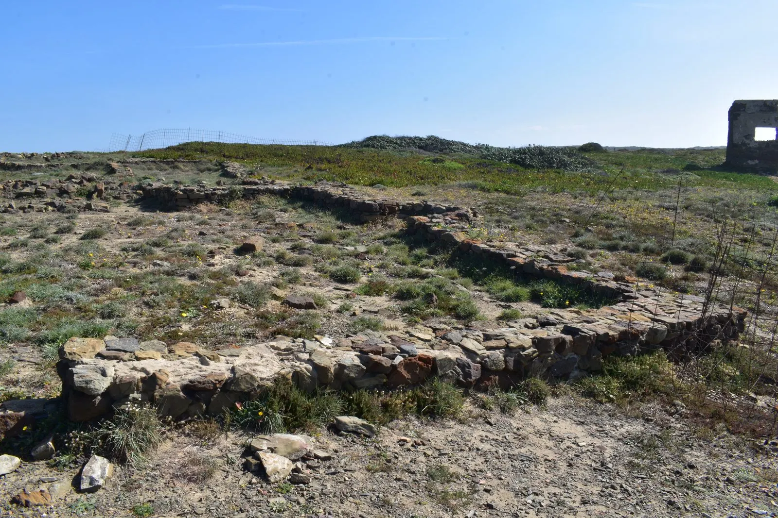
The SIPA describes the ruins of several buildings across four sectors, among them three mosques with qibla and mihrab. The walls were of plastered and whitewashed rammed earth on a foundation of schist, greywacke and sandstone masonry, with beaten-earth floors. To the southeast, where one entered, lies a necropolis with graves and inscribed funerary stelae. Separated by a wall is sector 4, a madrasa (Quranic school) with a large courtyard and cells. In sector 1, where the promontory narrows, several mosques are concentrated, one of them of large dimensions, together with residential structures; this is the zone of greatest activity in the ribat, where passage into the interior of the promontory was controlled, while the rest of the perimeter was naturally defended by the cliffs. Sector 2 has a mosque with annexes overlooking the sea; at the tip, sector 3 includes a mosque with a prayer wall and a minaret of circular plan.
Campaigns and enhancement
According to the SIPA, the archaeological work followed this sequence:
- 2001: identification by Mário and Rosa Varela Gomes, with clearing and surface excavation of two sectors, supported by the municipality and local bodies.
- 2002 (August): excavations directed by the same couple, published by them in the Revista Portuguesa de Arqueologia (vol. 7, 2004, according to the SIPA bibliography).
- 2011 (August): discovery of a mosque, 21 graves and a funerary slab with inscriptions in Arabic.
- 2014: campaign at the entrance to the complex and in delimiting the necropolis, with two inscribed stelae.
- 2016: enhancement project promoted by the municipality and the Ministry of Culture, with new excavations, an interpretation centre and a museum planned.
- 2019 (30 August): dispatch declaring the public utility of the expropriation of four land parcels, to guarantee the protection, investigation, enhancement and interpretation of the ribat.
From the fourteenth century, the minaret was reused as a watchtower, which gave rise to the place name Ponta da Atalaia. The SIPA records the earliest known reference to the site, in the História de Portugal, in 1786. What was done on the ground after 2019 is not documented in the official sources we consulted.
Classification
The Atlas do Património Cultural, consulted on 5 November 2026, records the Ribat da Arrifana (NINV 74247) as a National Monument, classified by Decree No. 25/2013, Diário da República, 1st series, No. 142, of 25 July 2013. The special protection zone was set by Ordinance No. 498/2023, Diário da República, 2nd series, No. 184, of 21 September 2023, and the record indicates the existence of restrictions.
Preparing a visit
The SIPA locates the site in Aljezur, on the Ponta da Atalaia, near the Vale da Telha, less than a hundred metres from the ocean, with views towards Cape St Vincent to the south and Cape Sardão to the north. At our consultation on 5 November 2026, we found no official information on opening hours, guided access or a functioning interpretation centre, so please confirm with the Câmara Municipal de Aljezur before going and respect any fencing. For the territory, see also the Algarve; the Moorish and Islamic heritage and Islamic art in Portugal provide the cultural context.
Photograph: Bextrel, 14 March 2020, Ribat da Arrifana - Sector I 1 - 14.03.2020.jpg, licence CC BY-SA 4.0, resized and compressed for the web, without altering the composition.
Frequently asked questions
- What is a ribat?
- A ribat is an Islamic convent-fortress, occupied by warrior monks. The SIPA identifies the Arrifana ribat as the only known ribat in Portugal and the second in the Iberian Peninsula, after that of Guardamar (Alicante).
- Who founded it and when?
- According to the SIPA, it was founded on the initiative of Ibn Qasi, a native of Silves, around 1130 (probable date). It was abandoned from 1151, after the founder's assassination.
- Is it protected?
- Yes, as a National Monument, by Decree No. 25/2013, published in the Diário da República, 1st series, No. 142, of 25 July 2013. The special protection zone was set by Ordinance No. 498/2023, of 21 September.
- Can I visit it?
- We found no official information on opening hours or visiting rules as of our consultation on 5 November 2026. Please confirm with the Câmara Municipal de Aljezur.
Sources
- Património Cultural, I.P. — Atlas do Património Classificado (Ribat da Arrifana, NINV 74247)
- Diário da República — Decreto n.º 25/2013, de 25 de julho de 2013
- DGPC — SIPA, Ribat da Arrifana (IPA.00031965)
- Património Cultural, I.P. — Ficha do Ribat da Arrifana (registo n.º 13246353)
- Wikidata — Ribat da Arrifana (Q17390062)
Keep exploring
Heritage nearby
More places to discover from here. Approximate straight-line distances, within 50 km.