Monuments
Pena de Aguiar Castle
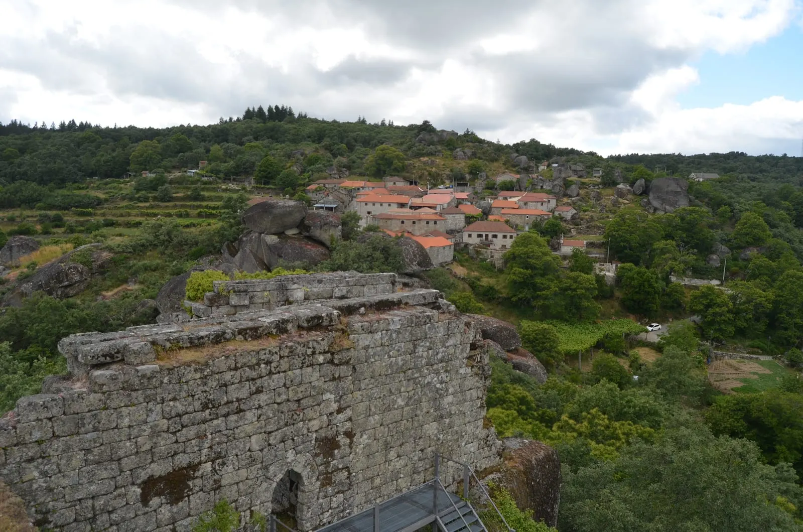
Pena de Aguiar Castle, in Vila Pouca de Aguiar: a rock-built castle on a granite outcrop, head of the Terra de Aguiar, a National Monument since 1982.
- Location
- Pena de Aguiar, Telões, Vila Pouca de Aguiar, Vila Real
- Built
- transição dos sécs. XI–XII (conjunto atual, segundo o registo nacional); barbacã e torre de finais do séc. XIV
The Pena de Aguiar Castle, also called Castelo de Aguiar or Castelo de Aguiar da Pena, is a rock castle. It sits on a huge granite outcrop in the locality of Pena de Aguiar, in the civil parish of Telões, municipality of Vila Pouca de Aguiar. The Municipality describes it as a singular combination of nature and human ingenuity: the walls fit into the boulders and make use of them as part of the defence. From the top, the whole valley of Aguiar can be seen.
A hill occupied since Roman times
According to the national register of Cultural Heritage, I.P., the military occupation of the hill goes back to the Roman period. A defensive redoubt is said to have been built then to protect the road linking Chaves (Aquae Flaviae) and Lamego (Lamecum). The register does not describe remains of that redoubt, and what is seen today is medieval.
In the 11th century, there are references to the conquest of the castle by the troops of Fernando Magno, King of León. At the end of that century, Pena de Aguiar was the seat of an important territory. The castle was the head of that circumscription, entrusted to a nobleman close to the monarchy.
The medieval castle
The register accepts that the complex known today may have been defined at the turn of the 11th to the 12th century. The works may have lasted somewhat longer and reached the reign of D. Sancho I. The Municipality gives a different chronology: it places the origins in the 9th and 10th centuries. It adds that the inquiries of 1220 refer to a fortress in operation, which could have included a seigniorial residence.
In the following centuries, the castle was transformed. The most notable campaign, according to the register, was that of the late 14th century, in the context of the Fernandine Wars against Castile. From this phase date the barbican and the tower, or arrow-slit hall, that crown the highest part of the castle.
What can be seen
The barbican is an enclosure of irregular quadrangular plan, adapted to the terrain, which originally had at least two storeys. The adjoining tower preserves a vaulted chamber, probably converted into a cistern. Above it there were other rooms, now ruined. The Municipality mentions a viewpoint set at the highest point of the fortification, with a panoramic view over the valley of Aguiar.
Abandonment
The national register acknowledges that little is still known about the last phases of occupation. It attributes the definitive abandonment to the turn of the 16th century. At that time, gunpowder artillery changed the way wars were fought, and medieval castles, tall and vertical, lost their military usefulness.
Classification and protection
The castle is a National Monument under Decree No. 28/82, of 26 February 1982, published in the Diário da República, I Série, No. 47. In Article 1, the decree classifies, in the district of Vila Real and municipality of Vila Pouca de Aguiar, the “Castelo de Pena de Aguiar, na freguesia de Telões”. The national register does not indicate a special protection zone. The Municipality notes that the monument lies within a classified natural area. The castle is not part of any World Heritage property.
Preparing the visit
When consulted on 5 November 2026, the webpage of the Municipality of Vila Pouca de Aguiar indicated that the castle and its natural surroundings can be visited independently, without booking. It also stated that the site has easy access. The page did not publish opening hours or prices. It gave the GPS coordinates 41.469694, -7.680190 and made a leaflet available. Please confirm the conditions on the municipal page for the castle.
In the same municipality lie the Tresminas Roman Mines, another testimony of the Roman presence in the region. Vila Real is the capital of the district. Further north, the castles of Chaves and Montalegre show other fortresses of the Alto Tâmega and Barroso. To continue, see Norte and the network of castles of Portugal.
Photograph by Pedro from Maia (Porto), Portugal, of 11 June 2020. Original on Wikimedia Commons, under CC BY 2.0; resized and compressed for the web, without altering the composition.
Frequently asked questions
- When was Pena de Aguiar Castle built?
- The national register of Cultural Heritage, I.P. accepts that the complex as it is known today may have been defined at the turn of the 11th to the 12th century, with works that may have continued into the reign of D. Sancho I. The Municipality of Vila Pouca de Aguiar places its origins in the 9th and 10th centuries and notes that the inquiries of 1220 refer to a fortress in operation.
- What remains of the castle?
- Granite walls adapted to the boulders remain and, at the highest point, the barbican of irregular quadrangular plan and an adjoining tower with a vaulted chamber. The national register dates these elements to the campaign of the late 14th century.
- Is the castle classified?
- Yes. It is a National Monument under Decree No. 28/82, published in the Diário da República, I Série, No. 47, of 26 February 1982.
- Is a booking needed to visit?
- When consulted on 5 November 2026, the Municipality's webpage indicated that the castle and its surroundings can be visited independently, without booking. There is a viewpoint at the highest point of the fortification.
Sources
- Património Cultural, I.P. — Castelo de Pena de Aguiar (71205)
- Património Cultural, I.P. — Atlas do Património Classificado, Castelo de Pena de Aguiar (NINV 4569)
- Diário da República — Decreto n.º 28/82, de 26 de fevereiro
- Município de Vila Pouca de Aguiar — Castelo de Aguiar da Pena
- Wikidata — Castelo de Pena de Aguiar (Q5049809)
Keep exploring
Heritage nearby
More places to discover from here. Approximate straight-line distances, within 50 km.