Monuments
Penamacor Castle
Penamacor Castle: walled town on the Beira Baixa border, granted to the Templars in 1189, with a 16th-century keep and bastions. National Monument since 2013.
- Location
- Penamacor, Castelo Branco
- Built
- Finais do séc. XII – séc. XIV; torre de menagem com remate do séc. XVI; baluartes do séc. XVII
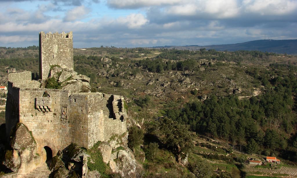
The Penamacor Castle occupies the Cimo da Vila, a granite elevation that overlooks the Beira Baixa border in the district of Castelo Branco. The classification decree points out that the Monsanto Castle can be seen from here: the two fortresses formed part of the same border defence line. Of what was, according to the same text, one of the most powerful castles in Beira, little remains. That little is enough to read eight centuries of military and municipal history: a tall, closed keep, the former Town Hall above the town gate, sections of wall and remains of bastions.
Templars and crown
The national register of the Cultural Heritage, I.P. links the castle’s origins to 1189, the year D. Sancho I granted the town to the Master of the Order of the Temple, D. Gualdim Pais. The construction of the fortified enclosure is usually placed at that moment or shortly after. The register admits that an earlier fortification may have existed on the site, as happened with other grants to the Templars, but excavations on the Cimo da Vila have not yet confirmed it. The municipality, for its part, presents Penamacor as a royal town after the Reconquest and dates the charter of D. Sancho I to 1209.
Almost nothing is known of the Romanesque castle. According to the register, the surviving remains already belong to the Late Middle Ages. In the reign of D. Dinis, walling works were carried out, and the 2013 decree attributes a wider perimeter to this campaign. The barbican and other elements date from the reigns of D. Fernando and D. João I. The medieval town had an oval enclosure, typical of Gothic walled towns, and it can still be traced along Rua de São Pedro.
The keep
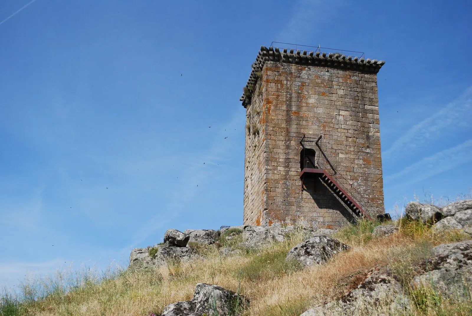
The strongest element of the complex is a square-plan tower set on a granite outcrop. Almost without windows, it has a single doorway, raised high above the ground, which required a removable staircase. The municipality indicates that this doorway is about six metres from the base and that it is now reached by an external staircase. The crowning feature was a continuous machicolated gallery on corbels, a solution that the national register considers relatively rare in Portugal. The register dates it to the beginning of the 16th century, because Duarte de Armas, who drew the town at that time, noted that the keep was still unfinished.
The naming of the towers is not uncontested. The national register considers this tower the keep and notes that it was long, mistakenly, called the “Watch Tower”. The municipality also presents it as the keep and describes it as one of the last towers of medieval profile built in Portugal, with surveillance and residential functions. The 2013 decree, however, distinguishes a separate Watch Tower and identifies the former keep with the present Clock Tower. The latter is attached to the wall beside the town gates. The municipality dates it probably to the mid-14th century and states that the present battlements and belfry result from a mid-20th-century reconstruction, carried out to house the clock installed in 1956.
From the Town Hall to the bastions
In 1568, according to the national register, the Town Hall was built over the town’s north gate, in line with the wall. The ground floor is the passage itself into the enclosure, so the council thus controlled who entered and left. The municipality describes the tunnel-like entrance formed by the juxtaposition of a Gothic portal to the original Romanesque portal. The councillors met there until the 19th century. Afterwards, the building served as a military store and, according to the municipality, from 1949 as the seat of the initial core of the Municipal Museum; the national register gives 1943 for the museum’s installation in the former Town Hall.
During the War of the Restoration, the walls were reinforced. Under the command of the Marquis of Castelo Melhor, six bastions were built around the medieval fortification. The decree names, among what survives, the Outeiro and Cavaleiro redoubts. Next to the complex stands the pillory, bearing the date 1565 on the town’s coat of arms. The municipality considers it unique in the district, as it retains the rings on its iron hooks.
Dismantling and classification
The national register reports that the garrisons were maintained into the 18th century, but their abolition, in 1834, precipitated the destruction of the military system. The castle came to be used as a quarry. In 1867 the Santo António gate was demolished and, in 1874, the council authorised the dismantling of a bastion. The process continued through the first half of the 20th century.
Classification had a long course. In 1973, the proposal of the Directorate-General for Cultural Affairs was reviewed by the National Education Board and approved as a National Monument. Only in 2013 was the decree published. The castle is a National Monument under Decree no. 14/2013, published in the Diário da República, 1st series, no. 119, of 24 June 2013. The decree understands the castle as the whole walled area of the former medieval town and leaves the definition of the special protection zone to a later ordinance. When consulted on 5 November 2026, the Classified Heritage Atlas did not indicate an ordinance establishing a ZEP for this monument. The castle is not part of any UNESCO inscription. The municipality of Penamacor does, however, lie within the territory of the Naturtejo Geopark.
Preparing the visit
The visit is made on foot through the Cimo da Vila, from the centre of Penamacor. According to the municipality, the keep displays in a vaulted room part of the finds from the excavations of the alcazaba and the pillory, as well as a scale model of the former town based on the drawings of Duarte de Armas. From the top, the view reaches the Sierra de Gata, the Gardunha and Monsanto.
When consulted on 5 November 2026, the municipal page for the tower indicated visits by appointment and free admission, with the telephone number 277 394 106 and the address [email protected]. That page had not been updated since December 2020. Confirm the conditions with the municipality before going.
In the town, the Casa da Memória da Medicina Sefardita Ribeiro Sanches, opened in December 2021, connects Penamacor to the Rede de Judiarias de Portugal, of which the municipality was a founding member. To continue along the border, head to Monsanto, consult the itinerary for Centro de Portugal, or compare Penamacor with other castelos de Portugal.
Photograph by Concierge.2C, dated 11 June 2011. Original on Wikimedia Commons, under CC BY-SA 3.0; resized and compressed for the web, without altering the composition.
Frequently asked questions
- When was Penamacor Castle built?
- The national register links its origins to the grant of the town to D. Gualdim Pais, Master of the Order of the Temple, by D. Sancho I, in 1189. What stands today is mostly later: works under D. Dinis, the barbican of the reigns of D. Fernando and D. João I, the top of the keep at the beginning of the 16th century, and bastions from the War of the Restoration.
- Is Penamacor Castle a National Monument?
- Yes. It was classified by Decree no. 14/2013, published in the Diário da República, 1st series, no. 119, of 24 June 2013. The classification proposal dated from 1973, the year it was approved, but the decree was only published in 2013.
- What remains of the castle?
- According to the classification decree, what remains are the Keep and Watch Towers, the Outeiro and Cavaleiro redoubts, sections of the wall and the former Town Hall, built over the town's north gate. The medieval layout can still be read along Rua de São Pedro.
- Can the keep be visited?
- When consulted on 5 November 2026, the municipal page for the Torre de Menagem e Antigos Paços do Concelho indicated visits by appointment and free admission, with the contact 277 394 106. That page had not been updated since 2020, so it is advisable to confirm before going.
Sources
- Património Cultural, I.P. — Castelo de Penamacor, também denominado Fortaleza de Penamacor (73056)
- Património Cultural, I.P. — Atlas do Património Classificado, Castelo de Penamacor (NINV 142)
- Diário da República — Decreto n.º 14/2013, de 24 de junho
- Município de Penamacor — Castelo de Penamacor, Torre de Menagem
- Município de Penamacor — Antiga Casa da Câmara
- Município de Penamacor — Torre do Relógio
- Município de Penamacor — Pelourinho
- Município de Penamacor — Torre de Menagem e Antigos Paços do Concelho
- Município de Penamacor — Museus
- Wikidata — Castelo de Penamacor (Q5049810)
Keep exploring
Heritage nearby
More places to discover from here. Approximate straight-line distances, within 50 km.