Places
Schist Villages of the Zêzere
Discover the six Schist Villages of the Zêzere: Álvaro, Barroca, Janeiro de Baixo, Janeiro de Cima, Mosteiro and Pedrógão Pequeno, with visiting tips.
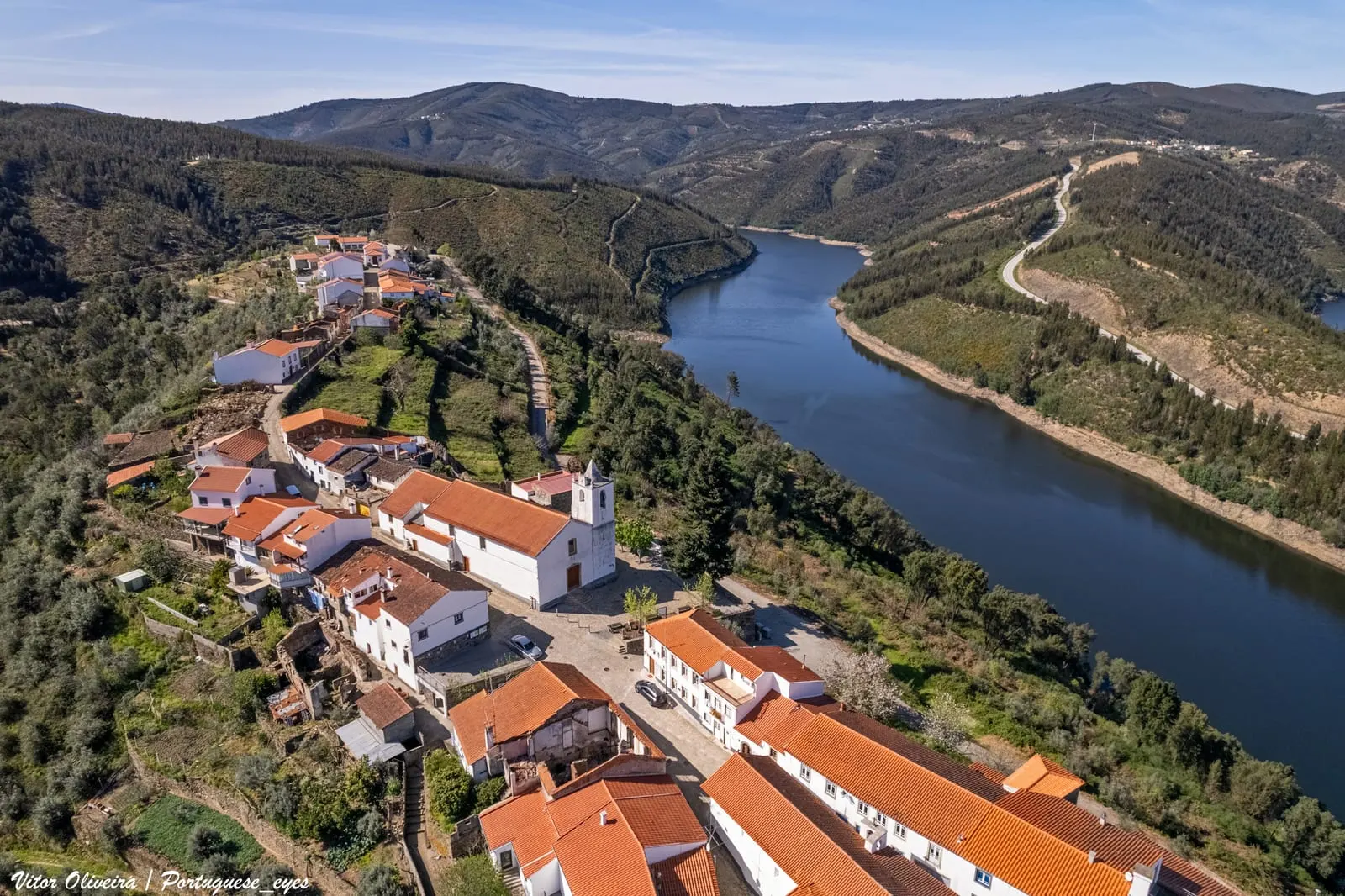
The Zêzere territory of the network of Schist Villages follows the river from the slopes of the Gardunha to the Cabril and Bouçã reservoirs. According to the official portal, consulted on 5 November 2026, it comprised six villages in five municipalities: Barroca and Janeiro de Cima (Fundão), Janeiro de Baixo (Pampilhosa da Serra), Álvaro (Oleiros), Pedrógão Pequeno (Sertã) and Mosteiro (Pedrógão Grande). Following the current downstream, Barroca is the first village of the network on the river; Pedrógão Pequeno overlooks the river crossing at Cabril.
The river explains almost everything: ferry crossings, weirs and mills, alluvial gold, riverbed pebbles set into the walls and, in the twentieth century, dams that transformed the landscape. This guide presents each village based on the network’s official records and the national register of classified heritage. Membership of the network is not, in itself, a heritage classification.
Barroca: manor houses and rock engravings by the river
Barroca, in the municipality of Fundão, occupies a hill on the left bank of the Zêzere, on the slopes of the Gardunha. It probably existed in the sixteenth century; the eighteenth century, judging by the houses built then, was likely its peak. The official record highlights an unusual ensemble for the network: aristocratic houses of the eighteenth and nineteenth centuries built entirely in schist, along Rua 5 de Outubro, with dates carved in 1772 and 1839.
The largest is the Casa Grande, an eighteenth-century manor of the Fabião family. In 1846–1847, during the Patuleia, Fabião António Leitão led from here the so-called «Guerrilha do Fabião» and issued official correspondence as administrator of the Fundão municipality. Today the house hosts the Centro Dinamizador das Aldeias do Xisto, and the village record presents Barroca as the seat of the network and its shops. In the twentieth century the Panasqueira Mines brought employment; the spoil heaps of Cabeço do Pião still mark the landscape. Two footbridges lead to the opposite bank, where there are rock engravings; by the river are a weir, a mill and slabs of an old paved road. The chapels of Nossa Senhora da Agonia (1713) and São Romão (1720) complete the route.
Janeiro de Cima and Janeiro de Baixo: white pebbles and crossings
Janeiro de Cima, also in Fundão, lies on a flat area of the left bank, surrounded by farmland. Its schist walls include rolled white pebbles collected from the riverbed, and the narrow streets are arranged around the Old Church. The official record mentions private buildings of the seventeenth and eighteenth centuries, a Chapel of the Holy Spirit probably of sixteenth-century origin (rebuilt in 1994) and the Casa das Tecedeiras, dedicated to weaving. The call «Ó da barca!» (“Hello, the ferry!”) recalls the crossing that linked the two banks. Gold flakes were found in the river, which motivated mining works.
On the other side, Janeiro de Baixo, in the municipality of Pampilhosa da Serra, rests on a rocky spur of the right bank that the Zêzere must skirt. An anthropomorphic tomb nearby points to early medieval settlement, linked by the official record to gold mining; the church appears in the parish survey of 1320. It was a commandery of the Order of Christ until at least 1679 and belonged to the municipality of Fajão until 1855. The walls also use pale river pebbles. To see: the schist diving fountain, probably eighteenth-century; the former school of the Plano dos Centenários (see Estado Novo architecture); the recovered shoeing trough; and the rock-carved water mill, now in ruins.
Álvaro: the village on the ridge
Álvaro, in the municipality of Oleiros, stretches along a narrow ridge between the Ribeira de Alvelos and the Zêzere, now transformed into the Cabril reservoir. In 1881, the author Pimentel, cited by the official record, described a tongue of land that «only admits one street». It belonged to the Order of Malta: in 1381, King Fernando recognised the Order’s claim over the commandery, and in 1455 Afonso V granted it to Gomes Martins de Lemos. It received a new charter from Manuel I in 1514 and was integrated as a parish in the municipality of Oleiros in 1836. The bridge over the Zêzere only arrived in 1983; until then, crossing was by ferry.
Although it is one of the network’s «white villages», the dominant material is schist, covered by whitewashed render. The religious ensemble is unusually rich: seven chapels in the village and surroundings, the Mother Church of São Tiago Maior and the Chapel of the Misericórdia, whose construction the official record dates to 1597. This chapel is registered as of Municipal Interest (Decree no. 67/97, of 31 December). On charitable institutions, see hospitals and misericórdias. The village record lists the Meandros do Zêzere as a geosite of the Naturtejo Geopark, which covers the municipality of Oleiros.
Pedrógão Pequeno: granite, hillfort and Philippine bridge
Pedrógão Pequeno, in the municipality of Sertã, sits on a small outcrop of granite surrounded by schist: it is a granite «white village», rendered and whitewashed mainly from the 1950s–1960s. On the Monte da Senhora da Confiança there is a hillfort that has never been excavated. A stretch of paved road links it to the village (see Roman roads), and an altar to Nabia, from the first century, is now in the National Museum of Archaeology. The official record notes the Templar charter of 1174, elevation to town status during the reign of Afonso V, the Manueline charter of 1513 and the abolition of the municipality in 1836.
The national register includes three listed properties linked to the village. The pillory is a Property of Public Interest (Decree no. 23 122, of 11 October 1933; see pillories). The Mother Church has the same category (Decree no. 45/93, of 30 November). The Ponte do Cabril, between Pedrógão Pequeno and Pedrógão Grande, is a National Monument under Decree no. 28/82, of 26 February. The network’s Xistopédia identifies the Philippine bridge as a National Monument and dates it to 1607–1610. It is built of granite, with three arches, the largest spanning 22 metres. Until the Cabril dam, inaugurated in 1954, it was the only link to Pedrógão Grande. There is also the nineteenth-century school endowed by Eduardo Conceição e Silva (1888) and the Way of the Cross up to the chapel of Senhora da Confiança (1902).
Mosteiro: the village of the Ribeira de Pera
Mosteiro, in the municipality of Pedrógão Grande, is the exception in this territory: it is not on the Zêzere but in the valley of the Ribeira de Pera, which descends from the Serra da Lousã and joins the Zêzere at the Bouçã reservoir. The village lies on both banks, mainly the left, and has a river beach within the settlement. The official record acknowledges that little is known of its history. The chapel has elements from the fifteenth and sixteenth centuries, and the name may derive from an ancient hermitage of which no traces remain. The road and the school date from 1952; electricity arrived in 1976. Schist walls bonded with clay, rotary mills, irrigation channels and a shared irrigation system overseen by a «zelador» elected every year show how water organised local life.
Planning your visit
Barroca and the two Janeiros lie close together, on the upstream stretch. Álvaro, above the Cabril reservoir, and Pedrógão Pequeno and Mosteiro, near the IC8, group together downstream. On 5 November 2026, the official records listed several Schist Trails (among them the PR1 FND of Barroca, with the rock engravings; the PR2 FND of Janeiro de Cima; the PR1 and PR2 OLR of Álvaro; and the PR1 and PR2 SRT of Pedrógão Pequeno) and stages of the Grande Rota do Zêzere (GR33), on foot, by bicycle and by canoe. The same agenda announced a Mycological Day in Janeiro de Cima on 21 November 2026.
Check dates, trail conditions and access to the river beaches in the official village records or with the municipalities. Many of the houses mentioned are privately owned. The neighbouring mountain villages are covered in Schist Villages of the Serra do Açor and Schist Villages of the Serra da Lousã. For building technique, see schist houses; for the region, the Centro.
Photograph by Vitor Oliveira, 5 April 2023. Original on Wikimedia Commons, under CC BY-SA 2.0; resized and compressed for the web, without altering the composition.

Frequently asked questions
- What are the Schist Villages of the Zêzere?
- According to the official portal, consulted on 5 November 2026, there were six: Álvaro (Oleiros), Barroca and Janeiro de Cima (Fundão), Janeiro de Baixo (Pampilhosa da Serra), Mosteiro (Pedrógão Grande) and Pedrógão Pequeno (Sertã).
- Are they all on the banks of the Zêzere?
- Five lie on the river or beside its reservoirs. Mosteiro lies in the valley of the Ribeira de Pera, a tributary that joins the Zêzere at the Bouçã reservoir.
- What listed heritage exists in these villages?
- The national register includes, among others, the Ponte do Cabril (National Monument, 1982), the Mother Church and pillory of Pedrógão Pequeno (Properties of Public Interest), and the Chapel of the Misericórdia of Álvaro (Municipal Interest).
- Where are the Tejo-Ocreza villages?
- Água Formosa, Figueira, Martim Branco and Sarzedas form a separate territory of the network, further south, in the Tejo and Ocreza basins. They are not covered by this guide.
Sources
- Aldeias do Xisto — Território e unidades territoriais
- Aldeias do Xisto — Álvaro
- Aldeias do Xisto — Barroca
- Aldeias do Xisto — Janeiro de Baixo
- Aldeias do Xisto — Janeiro de Cima
- Aldeias do Xisto — Mosteiro
- Aldeias do Xisto — Pedrógão Pequeno
- Aldeias do Xisto — Xistopédia: Ponte Filipina
- Património Cultural, I.P. — Atlas do Património Classificado (consulta por freguesia)
- Wikidata — povoações de Álvaro, Barroca, Janeiro de Baixo, Janeiro de Cima, Mosteiro e Pedrógão Pequeno