Archaeology
Dolmens of Castelo de Vide
Nine late Neolithic dolmens of Castelo de Vide, a National Monument since 1910, lie in the Serra de São Mamede; almost none have visitor facilities.
- Location
- Santiago Maior, Portalegre
- Built
- c. 3750–2500 a.C.
- Style
- Megalítico (dólmenes de câmara poligonal)
The municipality of Castelo de Vide, on the western slope of the Serra de São Mamede, has one of the highest densities of dolmens in the Alto Alentejo. The national register of Cultural Heritage includes nine dolmens classified as National Monuments and more than a dozen with protection of a lower grade. Almost none has visitor infrastructure: they are granite tombs isolated in enclosures, holm oak groves and farms, today partly reused as cattle shelters or storage. This guide gathers the nine, describes what the register says about each, and explains what to expect when visiting the territory surrounding the town of Castelo de Vide.
A landscape of tombs
A dolmen is a collective stone tomb: granite orthostats closed by one or more capstones (the “hat”), sometimes with an access passage and originally covered by an earthen and stone mound. In the municipality, the register generally places construction between the mid-4th and mid-3rd millennium BC, that is, between the Late Neolithic and the Chalcolithic. For the Nave do Grou and Alcogulo dolmens, the register offers a more precise dating, 3750–3125 BC, based on construction typology, and adds that the grave goods indicate continued use in the Chalcolithic.
The register also notes that megalithic monuments in the Sever River basin appear in documents from 1489, in the Ordenanzas del Concejo de Valencia de Alcántara, where they served as territorial markers, although it is nearly impossible to link those mentions to specific dolmens. The first published description of several dolmens in the municipality is due to Pereira da Costa, in 1868. The studies of Maria da Conceição Rodrigues (Archaeological Map of the municipality, 1975) and of Jorge de Oliveira (the project Neolithic and Megalithism in the Northeast Alentejo, with a campaign in 1990) underpin much of what is known today.
The nine dolmens that are National Monuments
All appear in the register as National Monuments, with reference to the decree of 16 June 1910 (Diário do Governo no. 136, 23 June 1910), the first major list of national monuments. In parentheses, the register code on imovel.patrimoniocultural.gov.pt.
- Anta de Couleiros (code 69823; civil parish of Santiago Maior). It forms part of the Coureleiros necropolis, with five monuments (the other four have classification as property of public interest). It is the largest: a polygonal chamber of seven orthostats, measuring 4.5 by 3.75 metres, with a capstone fallen inward and a parallel passage six metres long. It was excavated in 1990 by Jorge de Oliveira, who recovered the plan, the passage and the stone cairn; the grave goods include arrowheads, geometric microliths, polished stone axes, necklace beads and schist plaques. It also appears as Coureleiros II.
- Antas da Coutada de Alcogulo (70259; Santa Maria da Devesa). Despite the plural, it is a single monument, the best preserved in the Alcogulo necropolis: a chamber of about 3 metres, five orthostats in place, original capstone and a passage of about 4 metres with three covering slabs. It was reused as a shepherds’ shelter. Excavated in 1981 by the Archaeology Group of Castelo de Vide.
- Anta da Nave do Grou (70261; São João Baptista). Seven massive, almost square orthostats still in place; the fallen capstone was reset in 1992 by the Câmara. Chamber 2.5 by 1.5 metres; passage not confirmed. Excavated in 1982.
- Anta de Melriço (69822; Santiago Maior). Chamber 3.5 metres in diameter, with seven orthostats (four broken), 3.10 metres high and capstone in place. Pereira da Costa excavated it in the mid-19th century without useful results.
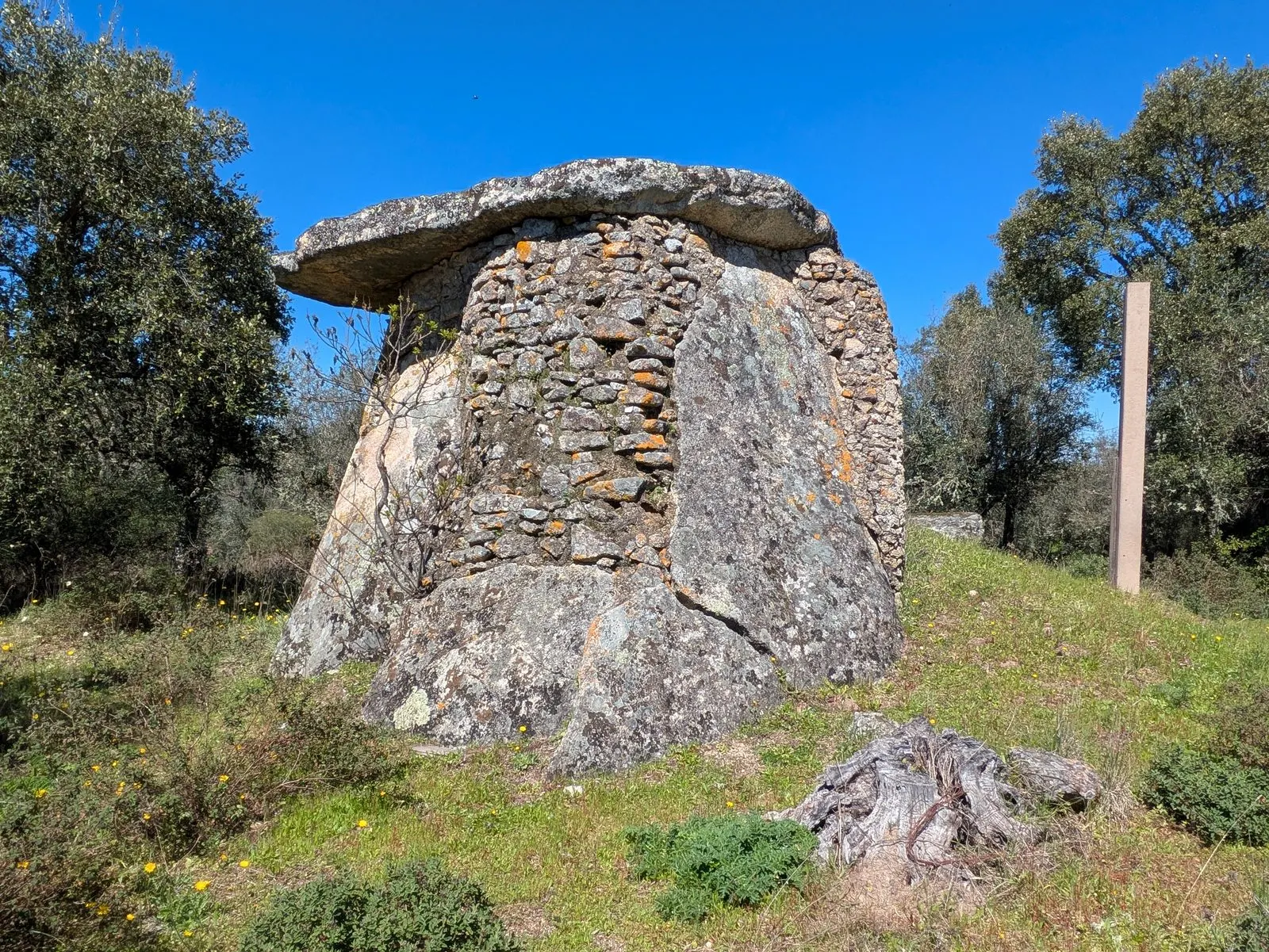
- Anta dos Pombais (70247; Santa Maria da Devesa), about 2 km from the town. Chamber about 3.5 metres in diameter and 2.20 metres high, converted into a shepherds’ shelter with openings blocked by masonry; some authors suggest a conversion into a chapel. It is the one shown in the photograph in this guide.
- Anta da Casa dos Galhardos (70165; Santa Maria da Devesa). Six of seven orthostats preserved, mound almost disappeared; excavated in 1982, with grave goods that have no published report, reaching into the Bronze Age.
- Anta das Tapadas de Pedro Álvaro (70246; Santa Maria da Devesa). Also called Anta do Pêro d’Alva; seven orthostats leaning inward, used as a henhouse and hidden behind a farmhouse. Never excavated.
- Anta de Fonte de Mouratão (70260; São João Baptista). Chamber 3 by 2.25 metres; a farmhouse was built against the dolmen, whitewashed and used as a henhouse. No excavations.
- Anta da Várzea dos Mourões (69821; Santiago Maior). Heavily destroyed, reused as a pigsty; in 1975 three orthostats survived, only one in place. No excavations. About 800 metres away stands the Anta do Cerejeiro, of lower classification.
Reading the group
What distinguishes the municipality is the variety of uses given to the dolmens after funerary use ended. Pombais, Fonte de Mouratão and Tapadas de Pedro Álvaro show how stone chambers served as pens, henhouses or shelters for centuries, which explains the dry-stone walls and mortar visible in the photograph. Couleiros and Alcogulo, excavated and with a recognisable passage, are the best for understanding the architecture. Regionally, these dolmens belong to the megalithism of the northeast Alentejo and the Serra de São Mamede, with polygonal chambers of seven orthostats. Further south, in the Évora region, megalithism reaches the scale of the Anta Grande do Zambujeiro, a useful contrast. For the general context, see also Portuguese megalithic art, the Neolithic and, in the same district, the dolmens of Elvas and Marvão.
How to visit
As of consultation on 5 November 2026, none of the nine register entries indicated legal access restrictions, but several dolmens stand beside rural houses or on farmland, and the entries publish neither opening hours nor directions. A tourism publication about the Anta de Melriço notes that, as it lies on private land, the visit must be requested from the Câmara Municipal. The safest course is to contact the Câmara Municipal de Castelo de Vide (Tourist Office, +351 245 908 227, according to a search on 5 November 2026; please confirm the contact on the municipal website) before going. Do not enter enclosed land without permission and close gates behind you. The register records carry the location of each monument.
Photograph by J iglar, 24 March 2025. Original on Wikimedia Commons, under CC BY-SA 4.0; resized and compressed for the web, without altering the composition.
Frequently asked questions
- How many dolmens in Castelo de Vide are National Monuments?
- Nine entries: Várzea dos Mourões, Pombais, Casa dos Galhardos, Nave do Grou, Tapadas de Pedro Álvaro, Couleiros, Fonte de Mouratão, Melriço and the Antas da Coutada de Alcogulo. All refer to the decree of 16 June 1910. There are also several other dolmens in the municipality with lower-grade protection.
- Can the dolmens of Castelo de Vide be visited?
- Several stand beside rural houses or on farmland. The national register lists no legal restrictions, but the Anta de Melriço, for example, is described as open to visit on request to the Câmara Municipal. It is advisable to confirm with the municipality before going.
- How old are they?
- The register dates them between the mid-4th and mid-3rd millennium BC (Late Neolithic and Chalcolithic). For the Nave do Grou and Alcogulo dolmens, the register proposes the Late Neolithic, between 3750 and 3125 BC, on grounds of construction typology.
- Which is the most complete?
- The Anta de Couleiros stands out for its well-differentiated chamber and passage, with a six-metre passage, and was excavated in 1990. The one in the Coutada de Alcogulo keeps its capstone in place and has a passage of about four metres.
Sources
- Património Cultural — Anta da Várzea dos Mourões
- Património Cultural — Anta de Melriço
- Património Cultural — Anta de Couleiros
- Património Cultural — Anta da Casa dos Galhardos
- Património Cultural — Anta das Tapadas de Pedro Álvaro
- Património Cultural — Anta dos Pombais
- Património Cultural — Antas da Coutada de Alcogulo
- Património Cultural — Anta de Fonte de Mouratão
- Património Cultural — Anta da Nave do Grou
- Património Cultural — Atlas do Património Classificado (serviço geográfico)
- Lifecooler — Anta de Melriço
- Diário do Governo n.º 136, de 23 de junho de 1910 — Decreto de 16 de junho de 1910
Keep exploring
Heritage nearby
More places to discover from here. Approximate straight-line distances, within 50 km.