Archaeology
Dolmens of Viseu District and Beira Alta
Ten nationally classified dolmens and passage tombs between Viseu, Dão-Lafões and the Serra da Estrela: passage chambers, red and black painting and cup-marks.
- Location
- Cunha Baixa, Mangualde, Viseu
- Style
- Megalítico (dólmenes de câmara poligonal e corredor, Beira Alta)
The plateau between Viseu, the Dão and the Serra da Estrela contains one of the most characteristic groups of dolmens in megalithic Portugal: polygonal granite chambers, sometimes with very long passages, and orthostats decorated with red and black paintings or with cup-marks. The Atlas of Classified Heritage lists several National Monuments here, most since the decree of 16 June 1910. This guide brings together ten: eight in Viseu District and two, Carapito and Paranhos, in Guarda District, which belong to the same Beira Alta landscape. For the general context, see the guide to megalithism and Portuguese megalithic art. The city of Viseu serves as a natural base.
Several records (Mamaltar, Cunha Baixa, Antelas, Juncais and Carapito) refer to the “Conjunto de Monumentos Megalíticos do Grupo de Viseu Dão Lafões” (Group of Megalithic Monuments of the Viseu Dão Lafões Group). The bibliography cited in the Mamaltar record refers to the “Viseu Group” studied by E. Shee in 1981, mainly for its painted and engraved art. The entries describe the monuments as Final Neolithic and Chalcolithic, which broadly corresponds to the regional Neolithic final phase and Chalcolithic.
Viseu municipality and surroundings
- Anta de Mamaltar do Vale de Fachas (Rio de Loba, Viseu; code 69768; NINV Atlas 4415). It lies at about 580 metres above sea level, on the Serra do Mundão, beside the Loba river, and forms part of a necropolis with two other monuments. The elongated polygonal chamber has nine granite orthostats that once reached three metres in height; three of them bore red and black paintings, now very faded, with traces of circular motifs. The passage, about 8.65 metres long, still has three capstones in place, one of them with a cup-mark. The mound, well preserved, stands about 2.5 metres high and 12 metres in diameter. The record places the construction at the transition from the 4th to the 3rd millennium BC and attributes the discovery to José Coelho, in 1912; there has been no further excavation since. It was classified in 1910 (then as Anta de Mamaltar, in the municipality of Albergaria-a-Velha), and the designation was corrected in 1993.
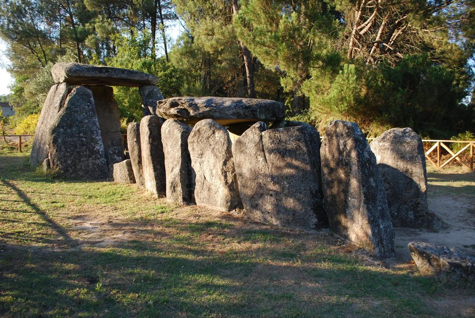
- Anta de Cunha Baixa (Cunha Baixa, Mangualde; code 70677; NINV 4292). This is the one pictured in this guide: a chamber of nine orthostats about 3 metres in diameter and 3.20 metres high, still covered by its capstone, and a passage of 7.17 metres flanked by eight orthostats on each side, with one capstone in place. It has cup-marks on the capstone and on one passage orthostat, and a much-deteriorated pictogram on another. No traces of the mound remain. The record dates it from the last quarter of the 4th millennium to the mid-3rd millennium BC, with finds extending into the Bronze Age. There are references from 1870, an excavation by Leite de Vasconcelos in 1902, and another in 1987 by Raquel Vilaça and Domingos da Cruz, which recovered the plan, discovered the engravings and carried out conservation work.
- Dólmen da Orca, or Lapa da Orca (Oliveira do Conde, Carregal do Sal; code 70598; NINV 4248). Known locally as Orca de Fiais da Telha, it lies on the Planalto do Ameal, between the Mondego and the Azenha stream. It retains the nine chamber orthostats, 3 metres high, and the capstone, together with a 7.5-metre passage with fifteen orthostats, beneath a mound of nearly 20 metres in diameter. It was studied in the 1980s and 1990s by J. C. Senna-Martínez and J. M. Quintã Ventura, with finds ranging from the Neolithic to the Bronze Age, and was consolidated afterwards, with fallen orthostats reset. Classified by Decree No. 735/74 of 21 December.
- Painted dolmen of Antelas (Pinheiro, Oliveira de Frades; code 70456; NINV 4317). On the Serra das Talhadas, the mound reaches up to 20 metres in diameter and about 2.5 metres in height, and covers a chamber of eight granite orthostats and a passage of just under 3.5 metres; between the entrance and the passage lies an intra-tumular segment of almost 5.5 metres, preceded by an oval stone-paved forecourt. All the chamber orthostats bear paintings and some engravings, in black and in two shades of red, in geometric, symbolic and figurative compositions organised around the headstone. The campaigns of the 1950s (Luís de Albuquerque e Castro, O. da Veiga Ferreira and Abel Viana) were followed by reburial of the monument, to preserve the paintings. Classified by Decree No. 29/90, and the designation was updated by Decree No. 45/93.
Vila Nova de Paiva, Penedono and Beira Alta
- Orca dos Juncais or Anta da Queiriga (Queiriga, Vila Nova de Paiva; code 69836; NINV 4410). Polygonal chamber of nine orthostats and a long passage, with eight orthostats on the north side. Six chamber orthostats and one passage orthostat bear paintings. Classified in 1910 (then in the municipality of Sátão) and reclassified by Decree No. 45/93. It was not on the requested list, but it belongs to the same group.
- Anta de Cas-Freires (Queiriga, Vila Nova de Paiva; NINV 4342). The Atlas also gives the names Anta de Casfreires and Orca do Tanque, and the 1910 decree; I was unable to consult the registration sheet, so nothing further is added.
- Dólmen da Capela de Nossa Senhora do Monte (Penela da Beira, Penedono; code 70452; NINV 4325). The Atlas lists it as a National Monument under Decree No. 44 075 of 5 December 1961. The record’s description could not be read.
- Anta da Arca (Arca e Varzielas, Oliveira de Frades; NINV 4316). The Atlas also gives the name Pedra dos Mouros and cites the 1910 decree, although the Antelas entry suggests that the Anta da Arca was not on that list, having been identified later. Its own sheet could not be read.
- Dólmen de Carapito I, or Casa da Moura (Carapito, Aguiar da Beira, Guarda District; code 70161; NINV 2895). A simple, large polygonal chamber with no identified passage. Excavations by V. Leisner and L. Ribeiro found a hearth with geometric microliths, variscite beads and polished axes, and later layers with plain pottery. Two orthostats bear engravings of circles, radiating lines, vertical wavy lines and concentric circles. Decree No. 735/74 of 21 December 1974 (the instrument names the district of Coimbra).
- Antas de Paranhos (Paranhos, Seia, Guarda District; code 71115; NINV 3011). There are two examples, but the highlight is a polygonal chamber tomb nearly 3 metres in diameter and 2 metres high at its maximum, with nine orthostats leaning inwards and the capstone in place; the passage is fragmented and partly buried. It was built in the Final Neolithic and reused in the Chalcolithic. Martins Sarmento examined it during the scientific expedition to the Serra da Estrela (1881). The record notes the risk posed by sand extraction at the site.
Reading the group
The long, well-differentiated passages (Mamaltar at 8.65 metres, Orca at 7.5, Cunha Baixa at 7.17) and the painted decoration, present at Antelas, Juncais and Mamaltar, distinguish this group. In the dolmens of Castelo de Vide, for example, the records describe mainly chambers with seven orthostats. The Antelas entry records that the monument was reburied after excavation, precisely to preserve the paintings.
How to visit
As of consultation on 5 November 2026, the register entries gave no opening hours or legal access restrictions. It is advisable to check with the Câmara Municipal de Viseu, Mangualde, Carregal do Sal, Oliveira de Frades, Vila Nova de Paiva, Penedono, Aguiar da Beira or Seia, as applicable, and not to enter private land without permission.
Photograph by Concierge.2C, 25 September 2011. Original on Wikimedia Commons, under CC BY-SA 3.0; resized and compressed for the web, without altering the composition.
Frequently asked questions
- How many nationally classified dolmens are there in Viseu District?
- This guide brings together ten monuments: eight in Viseu District (Mamaltar do Vale de Fachas, Cas-Freires, Orca dos Juncais, Cunha Baixa, Dólmen da Orca, Antelas, Anta da Arca and Dólmen da Capela de Nossa Senhora do Monte) and two in Guarda District (Carapito I and Paranhos), from the same Beira Alta megalithic landscape. The count corresponds to the Atlas of Classified Heritage as consulted on 5 November 2026.
- Which dolmens have paintings?
- According to the national register, the painted dolmen of Antelas has paintings on all the orthostats of the chamber; the Orca dos Juncais has paintings on six of the nine chamber orthostats and on one of the passage; the Mamaltar do Vale de Fachas preserves very faded traces on three orthostats.
- How old are these dolmens?
- The records generally place them between the end of the Neolithic and the Chalcolithic, between the last quarter of the 4th millennium and the mid-3rd millennium BC. Cunha Baixa and Mamaltar have dates of this kind; the finds from Cunha Baixa show later visits into the Bronze Age.
- Can I visit them?
- The records consulted do not give opening hours or access conditions, and do not mention legal restrictions. It is advisable to confirm with the relevant municipal council before going and to respect private property and enclosures.
Sources
- Património Cultural — Anta de Mamaltar do Vale de Fachas
- Património Cultural — Anta de Cunha Baixa
- Património Cultural — Dólmen da Orca, ou Lapa da Orca
- Património Cultural — Anta pintada de Antelas
- Património Cultural — Orca dos Juncais ou Anta da Queiriga
- Património Cultural — Dólmen de Carapito I
- Património Cultural — Antas de Paranhos
- Património Cultural — Atlas do Património Classificado (serviço geográfico)
- Diário do Governo n.º 136, de 23 de junho de 1910 — Decreto de 16 de junho de 1910
Keep exploring
Heritage nearby
More places to discover from here. Approximate straight-line distances, within 50 km.