Monuments
Bridge of Vilar de Mouros
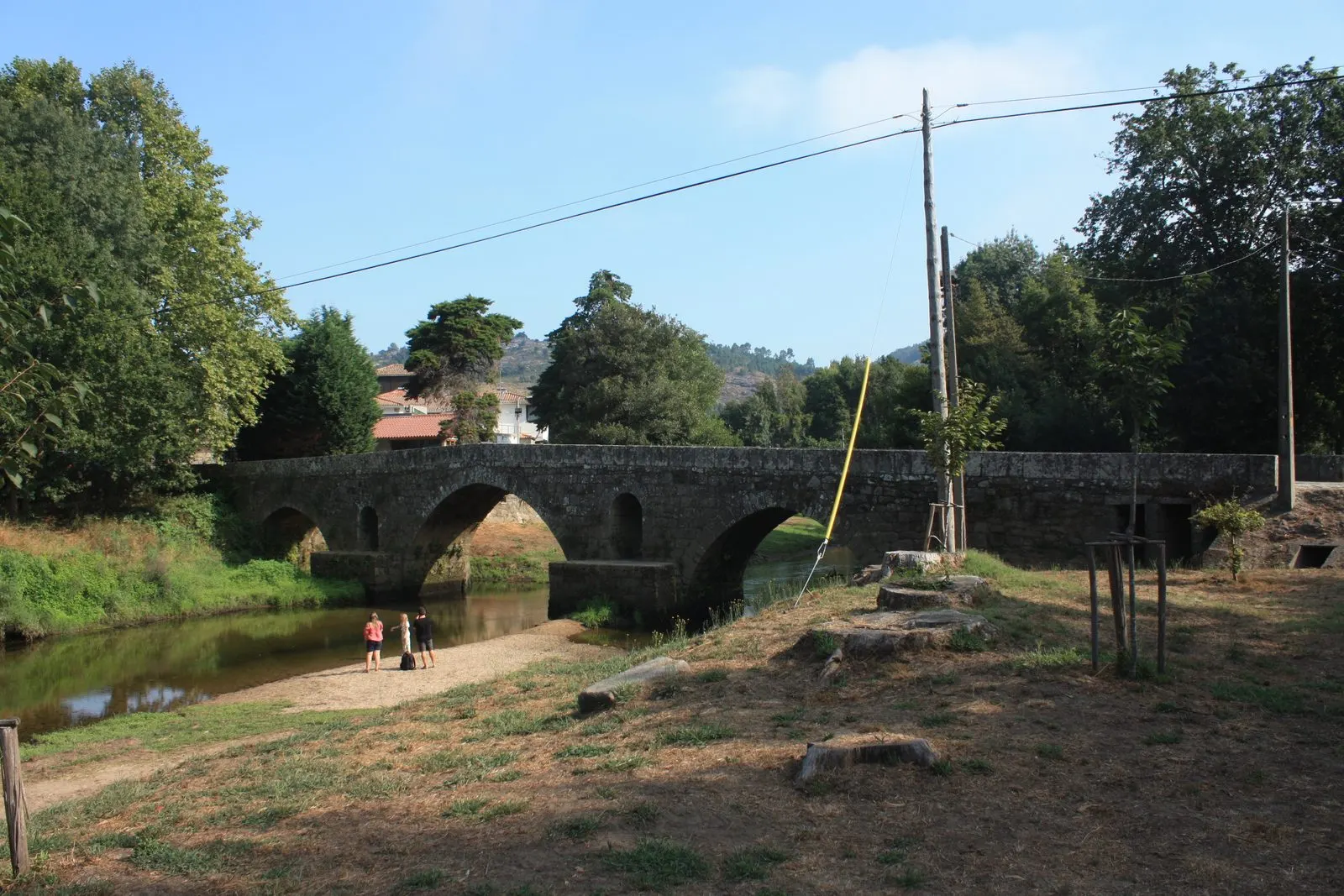
Vilar de Mouros Bridge, Caminha: a National Monument and Gothic landmark over the Coura River, with three arches, from the late 14th or early 15th century.
- Location
- Vilar de Mouros, Viana do Castelo
- Built
- finais do séc. XIV ou inícios do séc. XV (conjetural)
The Bridge of Vilar de Mouros crosses the River Coura in the municipality of Caminha, near its mouth. It is a granite bridge with three pointed arches, which Património Cultural classifies as a Gothic work. The official inventories describe it as a prototype of national Gothic bridges, modest in scale and practical in function. It is a good example of how the medieval bridges of the North followed a common model, with variations in size and ambition.
An old road over the Coura
According to the official record, an ancient medieval route crossed the river here, in a section of Alto Minho with gentle banks and dense woodland. The route linked Caminha with Valença and the Galician border, passing through Vilarelho, Venade, Argela and Vilar de Mouros. From this settlement the road forked north towards Seixas, avoiding the crossing of the Minho at Caminha by ferry, or continued inland along the Coura.
The bridge served this connection for centuries. The importance of the site grew in the modern period, as shown by the small chapel of Nossa Senhora da Piedade, associated with the bridge, and the monumentalised corner at the northern approach, where an 18th-century alminha, with a niche and stone cross, was built.
The Bridge of Lima model
The bridge repeats on a small scale the scheme of the Bridge of Lima: large, slightly pointed arches, interspersed with oculi (small round-arched openings) above prismatic cutwaters, which lighten the weight of the structure. The Património Cultural record notes that the double ridged deck (cavalete) and the odd number of arches are considered normal in Gothic bridge construction.
The details of the official record are these. The bridge rests on three pointed arches, built of narrow, elongated voussoirs, with the central one the largest. It has a prismatic cutwater upstream and triangular cutwaters downstream, ashlar parapets, and a cobbled paving with a central flagstone strip that divides it into two lanes. The deck forms a ridge and is preceded by access ramps.
The record emphasises the modesty of the work: there are no towers or battlements, the parapets are a simple low wall, and the number of spans confirms the relatively secondary status of the bridge. It compares it with the Bridge of Lima and other bridges of Entre-Douro-e-Minho, such as the Bridge of Barca, and concludes that there was a simplification of a more ambitious model, suited to the utilitarian character of most late medieval bridges in the North. For a medieval bridge with a tower and a different programme, see the Bridge and Tower of Ucanha.
Dating
The date is uncertain. The SIPA record gives the 14th-15th centuries as the probable and conjectural period, and the text of the record notes that bridge-building technology in the Late Middle Ages remained largely unchanged for more than two centuries, which precludes fine chronologies. It follows the proposal of Aníbal Ribeiro, for the late 14th or early 15th century, arguing that the Gothic reform of the Bridge of Lima in the second half of the 14th century would make it natural to date similar bridges to the following decade. SIPA also admits that the use of pointed arches with narrow voussoirs and oculi indicates a work probably promoted by the municipal council. Some authors have proposed a Roman origin, because the gradient of the deck is slight, but the hypothesis is not confirmed.
Classification and condition
The bridge is a National Monument by the Decree of 16 June 1910, published in the Diário do Governo no. 136, of 23 June 1910. Ownership is municipal.
The official record states that the bridge forms part of the National Road 301 and that the interventions carried out have been limited to consolidation. The SIPA chronology adds that, in 2004, it was closed to heavy traffic due to structural problems and an assessment was requested from the Faculty of Engineering of the University of Porto; that in 2006 DGEMN prepared a rehabilitation project; and that in October of that year heavy rains left the monument partially submerged. This information comes from archived copies of the records and does not replace consulting the current condition with the municipality of Caminha.
How to visit
The bridge is located at the Ponte locality, in the civil parish of Vilar de Mouros, and is accessible on foot from the village; the record indicates pedestrian and road use. The site is public and has no opening hours. When consulted on 5 November 2026, we did not find a recent official source on traffic restrictions, so please confirm with the municipality of Caminha whether you intend to cross by car or follow a walking route.
Photograph by Reis Quarteu, 7 August 2020. Original on Wikimedia Commons, under CC BY-SA 4.0; resized and compressed for the web, without altering the composition.
Frequently asked questions
- When was the Bridge of Vilar de Mouros built?
- The date of construction is not known. The official record considers it conjectural, from the 14th-15th centuries, and follows the proposal of Aníbal Ribeiro, who places it in the late 14th or early 15th century.
- How many arches does the bridge have?
- Three pointed arches, the central one being the largest. Above the cutwaters there are round-arched oculi, and the deck forms a double ridge (cavalete).
- Is the bridge Roman?
- Some authors have suggested a Roman origin, as has been proposed for the Bridge of Lima, but the hypothesis is not confirmed. The visible structure is Gothic.
- Is it classified?
- Yes, as a National Monument by decree of 16 June 1910, published in the Diário do Governo no. 136, of 23 June 1910.
Sources
- Património Cultural, I.P. — Ponte de Vilar de Mouros (registo 70178, NINV 4110), cópia arquivada de 2022
- SIPA — Ponte de Vilar de Mouros (IPA.00000438), cópia arquivada de 2020
- Património Cultural, I.P. — Atlas do Património Classificado (NINV 4110)
- Diário do Governo n.º 136, de 23 de junho de 1910
- Wikidata — Ponte de Vilar de Mouros (Q7228149)
Keep exploring
Heritage nearby
More places to discover from here. Approximate straight-line distances, within 50 km.