Archaeology
Dolmens of the Northern Coast and the Douro
Nine megalithic ensembles, National Monuments from Caminha to Arouca and the Alto Douro: dolmens with red paintings, engravings, corridors and mounds.
- Location
- Vilarinho da Castanheira, Carrazeda de Ansiães, Bragança
- Style
- Megalítico (antas e dólmenes de câmara poligonal e corredor)
In northern Portugal, dolmens appear almost always on mountain ridges and plateaux, in small groups of burial mounds, and many retain paintings or engravings on their orthostats. This guide brings together nine monuments or groups classified as National Monuments, from the Minho coast to the Douro basin: eight of them by the decree of 16 June 1910 (Diário do Governo no. 136, of 23 June 1910) and the Dólmen da Aliviada by Decree no. 26-A/92, of 1 June 1992. For general context, see megalithism, Portuguese megalithic art and the page for the Norte region.
Arouca
- Anta do Casal Mau (Santa Eulália, Arouca; Atlas NINV 2045). The Atlas also gives the names Necrópole Megalítica de Arreçaio and Mamoa de Arreçaio, and the 1910 decree. The registration file could not be consulted, so the structure is not described here.
- Dólmen da Aliviada or Mamoa 1 de Aliviada (Escariz, Arouca; NINV 2001). Also known as the Painted Dolmen of Escariz. It has been a National Monument since 1992, and the Geopark Arouca refers to its Neolithic origin. It can be linked to the Arouca Geopark and the Arouca Monastery, in the same concelho.
Baião and Penafiel
- Anta da Aboboreira (Campelo and Ovil, Baião; code 69838; NINV 3616). Built in the first half of the 3rd millennium BC, it is part of a group of five monuments in the megalithic necropolis of the Serra da Aboboreira. The mound, about 25 metres in diameter, is faced with stone; the polygonal chamber has eight side orthostats and a very large capstone, and the passage measures about 3.70 metres. It has red paintings on the orthostats, with star and circular motifs and a sub-rectangular figure with a trapezoidal base. It is also known as Chã de Parada or Dólmen da Fonte do Mel.
- Anta de Santa Marta (Penafiel; code 70169; NINV 3682). The record says it was possibly built in the 3rd millennium BC. The mound, about 27 metres in diameter, is badly damaged. The polygonal chamber is about 2.5 metres high, with seven interlocking orthostats bearing red paintings, and the capstone measures 3.3 by 2.1 metres. Of the passage, about 6 metres long, only ten orthostats are visible. It is also called Dólmen da Portela or Forno dos Mouros.
Minho: Barrosa and Serra de Soajo
- Anta da Barrosa (Vila Praia de Âncora, Caminha; code 70157; NINV 4098). Also called Lapa dos Mouros, it is the largest and best-preserved megalithic monument in the Âncora valley. It was excavated in 1879 by Francisco Martins Sarmento and later studied by João de Castro Nunes. The polygonal chamber has eight orthostats and a capstone; the passage is about 1.5 metres wide by 6 long, and there is no trace of a mound. Three slabs bear engravings of serpentiform motifs and U-shaped signs. Nearby, traces of Roman occupation from the 1st and 2nd centuries AD have been identified.
- Antas da Serra de Soajo (Soajo and Cabana Maior, Arcos de Valdevez; code 71222; NINV 4075). They were identified by Félix Alves Pereira, who recorded some sixty dolmens in the region between the late 19th and early 20th centuries. Today, in many cases, only the mound and a central depression remain. The Mezio group, on the left bank of the River Vez, is the best known: the Dólmen do Mezio retains its irregular polygonal chamber, its capstone and its passage facing east. Excavations recovered flint arrowheads, a spearhead and fragments of pottery.
Trás-os-Montes and the Upper Douro
- Anta de Fonte Coberta (Vila Chã, Alijó; code 70347; NINV 4437). Isolated on the Planalto da Chã, it is a “dolmen with vestibule”, a rare type in this area. Henrique Botelho explored it at the end of the 19th century; in 1938, João Manuel Cotelo Neiva carried out a systematic excavation. It retains the seven chamber orthostats (one fallen outside), the capstone, about 3.5 by 2 metres, and two slabs that appear to form a small vestibule. It has engraved cupmarks and grooves and, on one orthostat, red painted lines. The record mentions a recent conservation and restoration intervention, which reconstructed part of the mound and reset orthostats.
- Antas da Serra de Alvão (Alvão, Vila Pouca de Aguiar; NINV 4568). The Atlas also gives the name Chã de Arcas and the 1910 decree. The registration file was not consulted.
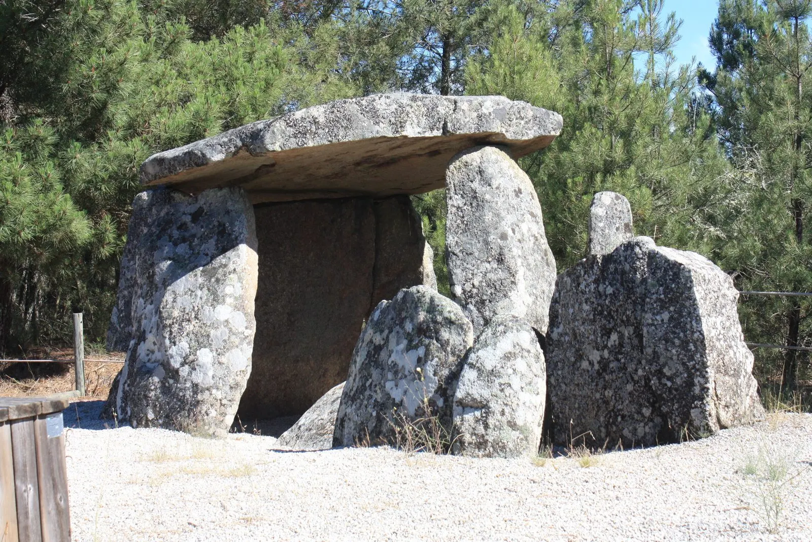
- Antas de Vilarinho (Vilarinho da Castanheira, Carrazeda de Ansiães; code 70231; NINV 2371). This is the one shown in this guide’s photograph. The 1910 group included several dolmens, but only one survives, the Pala da Moura, in good condition: polygonal chamber, capstone and granite passage, with no trace of a mound. The others were destroyed many years ago. The record refers to the Alto Douro Wine Region, which has its own page, in the field for the protection zone; the page on the Carrazeda de Ansiães castle completes a visit to the concelho.
Reading the group
The contrast with the Alentejo dolmens is clear. Here the records describe visible mounds, chambers with passages and painted or engraved art (Aboboreira, Santa Marta, Barrosa, Fonte Coberta), whereas in the Alentejo chambers with seven orthostats and cupmarks predominate. Destruction is frequent: the Soajo record attributes the disappearance of many dolmens to agricultural work, to the search for “treasure” and to the reuse of stone, and the Vilarinho record notes that only one of the dolmens classified in 1910 survives.
How to visit
When consulted on 5 November 2026, the registry records gave no opening hours or legal restrictions, and access information was vague. Confirm with the municipal council (Arouca, Baião, Penafiel, Arcos de Valdevez, Caminha, Alijó, Vila Pouca de Aguiar or Carrazeda de Ansiães) before going, and respect fences and private property.
Photograph by Reis Quarteu, 26 June 2021. Original on Wikimedia Commons, under CC BY-SA 4.0; resized and compressed for the web, without altering the composition.
Frequently asked questions
- Which dolmens in the Norte are National Monuments?
- This guide covers nine records: Casal Mau and Aliviada (Arouca), Aboboreira (Baião), Santa Marta (Penafiel), Serra de Soajo (Arcos de Valdevez), Barrosa (Caminha), Fonte Coberta (Alijó), Serra de Alvão (Vila Pouca de Aguiar) and Vilarinho (Carrazeda de Ansiães). All except Aliviada were classified by the decree of 16 June 1910.
- Are there dolmens with paintings?
- Yes. The national record mentions red paintings on the orthostats of the Aboboreira and Santa Marta dolmens, and a red line at Fonte Coberta. The Anta da Barrosa has engravings (serpentiform motifs and U-shaped signs) on three slabs.
- Which dolmen in Vilarinho survives?
- Of the dolmens classified in 1910 in Vilarinho da Castanheira, only the Pala da Moura remains, with a polygonal chamber, capstone and granite passage, according to the national record. The others were destroyed many years ago.
- Can I visit them?
- The records consulted do not give opening hours or legal access restrictions. It is advisable to confirm with the municipal council of the concelho before going and to respect private land.
Sources
- Património Cultural — Anta da Aboboreira
- Património Cultural — Anta de Santa Marta
- Património Cultural — Antas da Serra de Soajo
- Património Cultural — Anta da Barrosa
- Património Cultural — Anta de Fonte Coberta
- Património Cultural — Antas de Vilarinho
- Associação Geopark Arouca — Rota Vale do Arda e Zona Oeste
- Património Cultural — Atlas do Património Classificado (serviço geográfico)
- Diário do Governo n.º 136, de 23 de junho de 1910 — Decreto de 16 de junho de 1910
Keep exploring
Heritage nearby
More places to discover from here. Approximate straight-line distances, within 50 km.