Monuments
Fernandine Wall of Porto
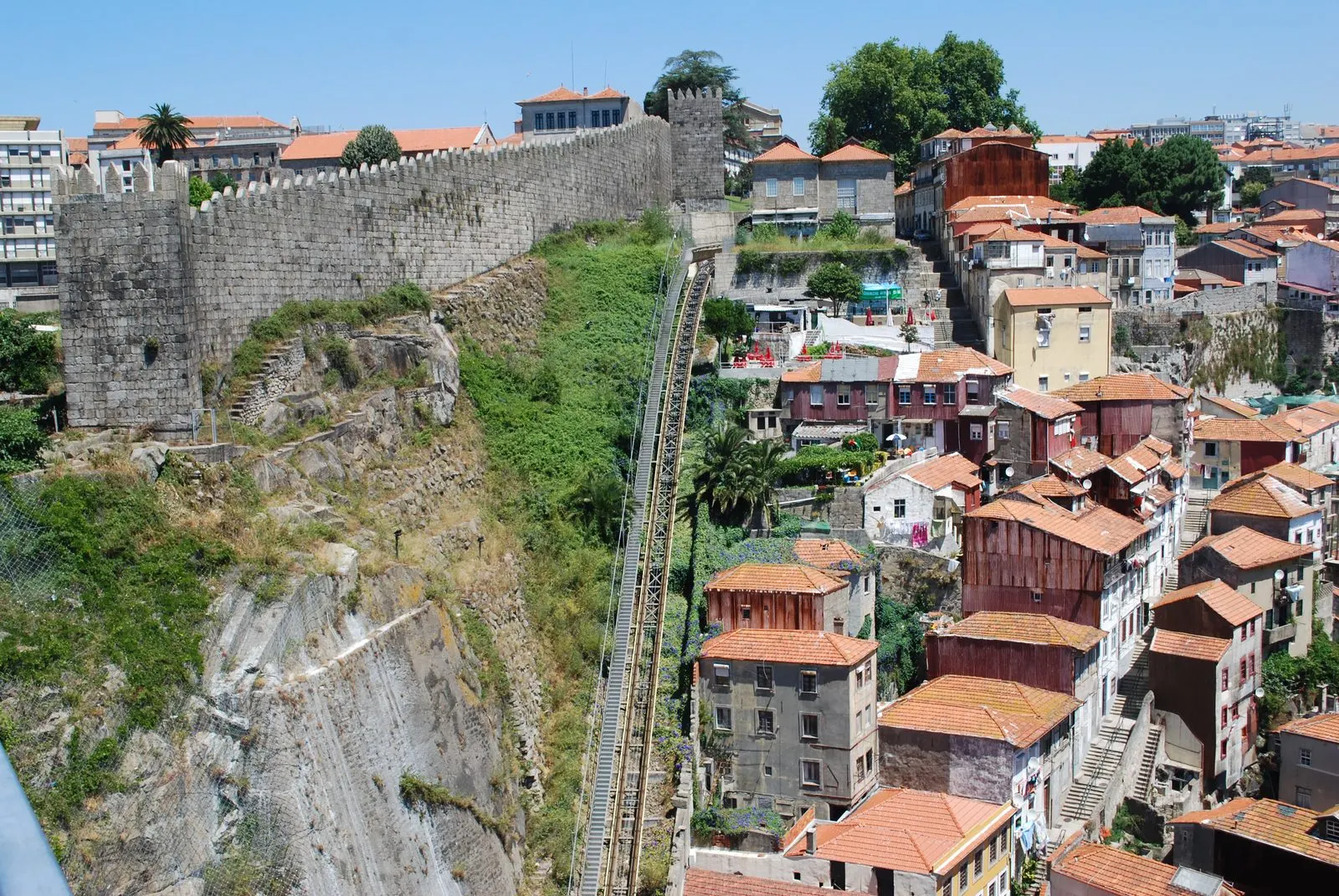
Fernandine Wall, Porto: 14th-century walls ordered in 1336, completed under King Fernando. See sections at Guindais and Caminho Novo. National Monument.
- Location
- Porto, Porto
- Built
- 1336–1376
Anyone crossing the Luís I Bridge towards Porto sees, atop the Guindais escarpment, a crenellated stretch of wall with square towers. It is the most visible section of the Fernandine Wall, the enclosure that in the 14th century came to surround the medieval city and the riverside zone. Only segments remain today, but the line of this wall continues to define what UNESCO recognises as the Historic Centre of Porto.
From the Romanesque enclosure to the new wall
Before the 14th-century wall, Porto had a smaller enclosure. The national register describes it as a 12th-century Romanesque wall of oval and irregular plan, around the Sé hill, with four main gates. One of them was the Porta de Vandoma, demolished by the Municipal Council in 1885. Vestiges of this first enclosure survive, although it was largely dismantled over the following centuries.
Within about two hundred years, the city grew well beyond this precinct, especially to the west and north, up to the heights of Vitória and Batalha. According to the national register, it was King Afonso IV who, in 1336, ordered the construction of a new wall. UNESCO explains that the new stone enclosure protected the two urban nuclei: the original medieval city and the port zone, until then outside the walls. It also states that the work was completed in 1376, during the reign of King Fernando, from whom the wall took its name.
The sources do not fully agree on the chronology. Visit Porto, the tourism portal of the Municipal Council, presents the wall as the work of King Fernando, built between 1368 and 1437 with money from a tax on wine. It adds that the wall measured about 3000 paces in length and 30 feet in height. These dates and measurements come from Visit Porto and do not appear in the national register.
Gates, roads and transformations
The national register estimates that about 10 000 people lived within the new walls. It cites the historians Manuel Luís Real and Rui Tavares, for whom the location of the gates reveals the layout of the old roads leaving the burgh for Foz and Bouças, Braga, Guimarães and Penafiel.
In the following centuries, the greatest changes affected the gates. According to the national register, the Porta Nova (1522) replaced the beach postern. The Porta dos Carros (1551) replaced a postern from the time of King João I. Both were destroyed in the 19th century, during the city’s urban modernisation. The Porta da Ribeira, to the east, had been demolished earlier, in the 18th century, during the reforms of the Almadas.
What can be seen today
According to UNESCO and Visit Porto, two sections survive. The Guindais section, beside Rua Arnaldo Gama, is the principal one and is clearly visible from the Luís I Bridge. It is a crenellated stretch of wall with a wall-walk and two square towers. The Caminho Novo section lies beside the Escadas do Caminho Novo. The national register also identifies the monument at Largo do Actor Dias, Rua Francisco da Rocha Soares, Rua da Madeira and Campo dos Mártires da Pátria. It associates the lookout mentioned in the official name with the flight of the Escadas dos Guindais.
The route of the enclosure is still recognisable in the urban fabric. The Igreja de Santa Clara stands beside the wall. The Sé do Porto occupies the centre of the oldest Romanesque precinct.
Twentieth-century restorations
According to the national register, the wall was heavily restored during the Estado Novo. The main works took place between 1959 and 1962, chiefly on the Guindais escarpment. During this campaign a Gothic tower-house was discovered on Rua de D. Pedro Pitões, opposite the Sé. Restored by the architect Rogério de Azevedo, it first housed the City History Office. More recent archaeological excavations, chiefly on the Sé hill, have added to what is known about the city’s defensive evolution.
Classification and World Heritage
The monument was classified as a National Monument under the designation Muralhas denominadas de D. Fernando e respectivo miradouro. The classification was made by Decree No. 11 454, published in the Diário do Governo, I series, No. 35, on 19 February 1926. The same decree classified other properties in the North.
The wall is also linked to World Heritage. In the summary of the property Centro Histórico do Porto, Ponte Luiz I e Mosteiro da Serra do Pilar, inscribed in 1996, UNESCO writes that the historic centre lies within the line of the Fernandine Wall. It also writes that this area preserves the two surviving sections. The national register associates the monument with this inscription. The wall has no separate UNESCO inscription of its own: it forms part of the area of the inscribed property.
Planning the visit
The sections of the wall lie beside public streets and stairways in the historic centre. The Escadas dos Guindais, which follow the old wall, give access to the principal section. When consulted on 5 November 2026, the Visit Porto page showed contradictory information: the status “open” beside a weekly timetable with every day marked “closed”. It also gave no conditions of access to the wall-walk. Before planning the climb onto the rampart, confirm with the Porto Municipal Council.
For context, see the city guide to Porto, the Norte region and the typology of urban walls and enclosures, where Porto appears among the cities with an old and a new enclosure. The network of castles of Portugal shows the same medieval military architecture outside the cities.
Photograph by Concierge.2C, dated 17 July 2010, submitted to Wiki Loves Monuments Portugal. Original on Wikimedia Commons, under CC BY-SA 3.0; resized and compressed for the web, without altering the composition.
Frequently asked questions
- Why is Porto's wall called Fernandine?
- Because it was completed during the reign of King Fernando. The national register states that construction was ordered by King Afonso IV in 1336, and UNESCO places its completion in 1376, already under King Fernando.
- What remains of the wall?
- According to UNESCO and Visit Porto, two sections survive: the Guindais section, beside Rua Arnaldo Gama, and the Caminho Novo section, beside the stairs of the same name. The route of the rest of the enclosure can still be read in the street grid.
- Is the wall listed?
- Yes. It is a National Monument, under the designation Muralhas denominadas de D. Fernando e respectivo miradouro (Walls known as D. Fernando and their lookout), by Decree No. 11 454, published in the Diário do Governo on 19 February 1926.
- Is the wall part of the World Heritage Site?
- Yes. UNESCO describes the Historic Centre of Porto, inscribed in 1996, as lying within the line of the Fernandine Wall and including the two surviving sections in that area. The national register associates the monument with the same inscription.
Sources
- Património Cultural, I.P. — Muralhas denominadas de D. Fernando e respectivo miradouro (71120)
- Património Cultural, I.P. — Atlas do Património Classificado, Muralhas denominadas de D. Fernando e respectivo miradouro (NINV 3753)
- Diário do Governo — Decreto n.º 11 454, de 19 de fevereiro de 1926
- UNESCO — Historic Centre of Oporto, Luiz I Bridge and Monastery of Serra do Pilar
- Visit Porto — Muralha Fernandina (Old city walls)
- Wikidata — Muralha Fernandina (Porto) (Q10333266)
Keep exploring
Heritage nearby
More places to discover from here. Approximate straight-line distances, within 50 km.