Archaeology
Dolmens of Central Alentejo: Redondo, Évora, Avis and Estremoz
Dolmens listed as National Monuments in Redondo, Freixo (Évora), Herdade da Ordem and Estremoz: seven-stone chambers, long corridors and difficult access.
- Location
- Redondo, Évora
- Style
- Megalítico (antas de câmara poligonal e corredor, megalitismo eborense)
Around Évora, Redondo and the Guadiana valley, central Alentejo has one of the largest concentrations of dolmens on the Iberian Peninsula. This guide covers six monuments or groups classified as National Monuments, all under the decree of 16 June 1910 (Diário do Governo n.º 136, 23 June 1910), which do not have their own pages: the Vidigueira, Tesouras and Candieira dolmens (Redondo), the Freixo dolmens (Évora), the dolmen of Herdade da Ordem and the Venda do Duque dolmen (Estremoz). Those in the rest of the municipality of Évora are covered in dolmens of the municipality of Évora; the largest of all has its own page. The megalithism guide explains the phenomenon in general.
Redondo
The municipality of Redondo has three dolmens classified as National Monuments, beside the Freixo stream.
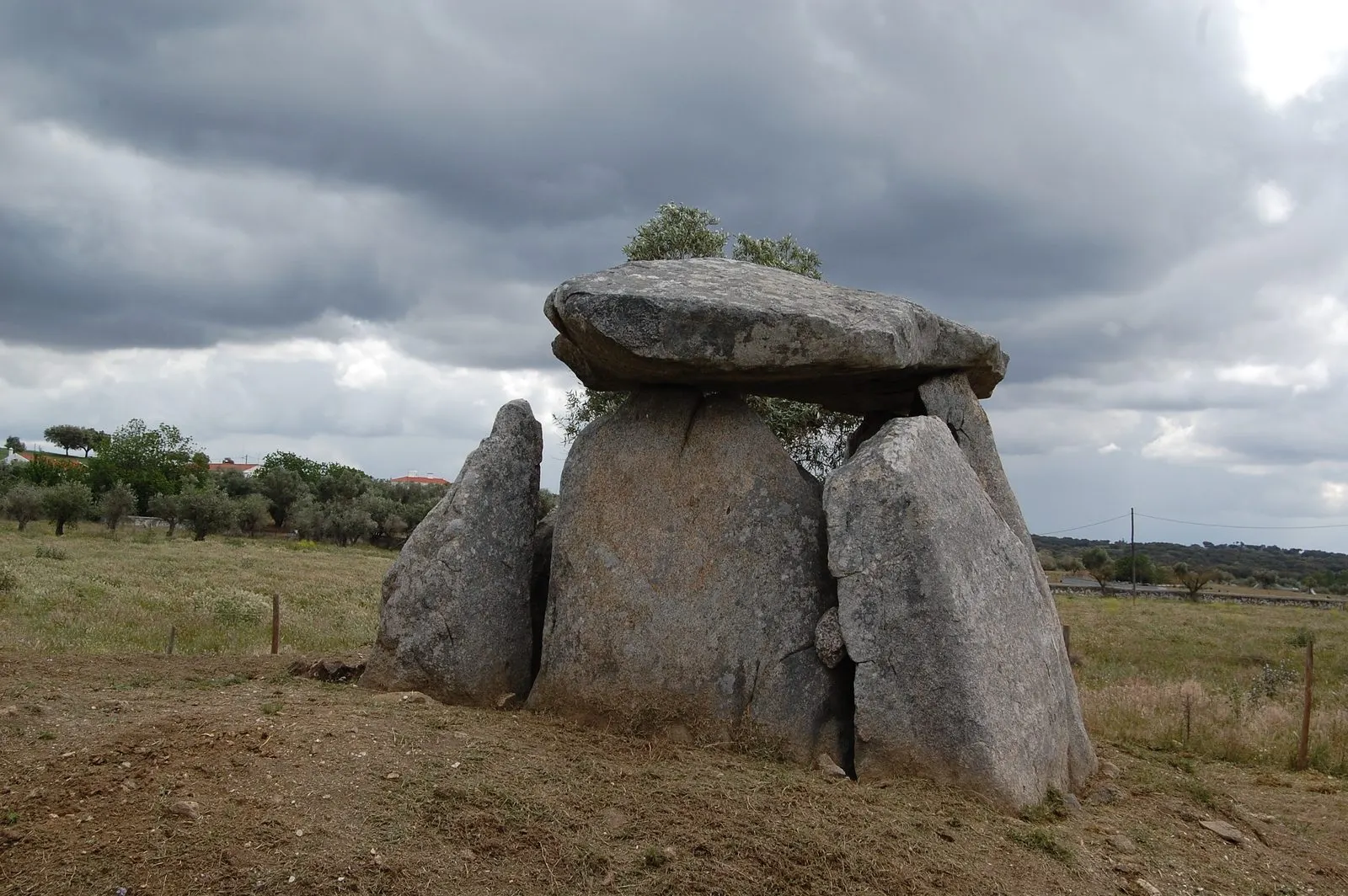
- Anta da Vidigueira (Redondo; code 70380; Atlas NINV 2785). It was erected between the 4th and 3rd millennia BC, isolated on a plain beside the Freixo stream, and the registry places it within the “Évora megalithism”, whose most notable example is the Anta Grande da Comenda da Igreja, in Montemor-o-Novo. It is well preserved: it retains in place seven chamber stones, the capstone (fractured) and four corridor stones. The mound, almost 8 metres in diameter, gives the monument the appearance of standing on a yard. It is the dolmen in this guide’s photograph and the reference point for its location (registry coordinates).
- Anta da Herdade das Tesouras (Redondo; code 70382; NINV 2784). Also called Anta da Herdade das Dessouras or Anta do Colmeeiro 1. On a small rise in the middle of the montado, beside the Freixo stream, it was published by Gabriel Pereira (1879), described by E. Cartailhac (1886) and by Georg Leisner (1949). It has an elongated polygonal chamber about 2.80 metres in diameter, seven granite stones of about 1.50 metres and a large fractured capstone, and a corridor of about 2.70 metres. Its features allow dating to the late Neolithic and Chalcolithic (3500–2000 BC). According to the record, it has been confused with the Anta das Dessouras 1, which is smaller and in worse condition. The record (C. Costeira, DGPC, 2018) classifies access as difficult and unsignposted.
- Anta da Herdade da Candieira (Redondo; NINV 2783). The Atlas lists it as a National Monument under the 1910 decree; the registry record could not be read, so no description is added.
Évora: the Freixo dolmens
- Antas da Herdade do Freixo (Torre de Coelheiros, Évora; code 70736; NINV 2779). The record describes them as a typical group of the “Évora megalithic universe”, built between the early 4th and mid-3rd millennia BC, investigated by Émile Cartailhac and José Leite de Vasconcelos in the 19th century. Materials excavated from “Anta 2” are now in the Musée des Antiquités Nationales, in Saint-Germain-en-Laye, and in the National Archaeology Museum, in Lisbon. The highlight is the Anta Grande do Freixo or Anta 1: an elongated polygonal chamber about 4 metres in diameter, seven stones still standing at about 4 metres high, a corridor about 12 metres long and about 2 metres wide at the entrance, of which three stones on the north side and one at the closing remain. The record notes that only three Herdade do Freixo de Cima dolmens are National Monuments, whereas the Atlas lists six (Freixo de Baixo 1, 2, 4 and 5 and Freixo de Cima 1 and 2). To get there, the record indicates the EN 256 (Évora–Reguengos de Monsaraz), the turn towards Viana do Alentejo and, about 4 km on, the local track heading southeast. This group is not included in the page on the dolmens of the municipality of Évora.
Herdade da Ordem
- Anta da Herdade da Ordem (code 70428; NINV 3490). The Atlas places it in Mora (parish of Pavia), but the registry record gives Avis (Alcórrego e Maranhão); the cited bibliography deals with megalithism in the Pavia area, in Mora. It is dolmen no. 1 of a necropolis of eight dolmens. The chamber is circular, about 4 metres in diameter, retains seven stones and the capstone in place; the corridor, about 7 metres long, has sixteen stones and a cover; the mound is clearly visible. The finds include plain and decorated pottery, pendants and beads of schist and green stone, pins, axes, adzes and schist plaques with red ochre. The registry dates it to the Neo-Chalcolithic. Another dolmen in Pavia, converted into a chapel, has its own page; for the regional model, see also the dolmens of Montemor-o-Novo.
Estremoz
- Anta da Venda do Duque (Évoramonte, Estremoz; NINV 2659). The Atlas lists it as a National Monument under the 1910 decree, and the registry record could not be read. For the town, see Estremoz.
What is left out
The original request included the Necrópole da Atalaia (Ourique) and the monuments of Quinta da Nora and Herdade da Marcela (Vila Real de Santo António). The Atalaia was classified by Decree no. 24/2013, and the Atlas does not describe it as a dolmen. The monuments of Vila Nova de Cacela appear in the Atlas as “funerary monuments” (1910 decree). The records of none could be read or confirmed as megalithic, so they are not treated here.
Reading the group
The Vidigueira and Freixo records point to the same model, that of the Anta Grande da Comenda da Igreja: a polygonal chamber of seven stones and a corridor. The variation lies in the dimensions, from a 2.80-metre chamber at Tesouras to 4 metres at Freixo and Ordem, and in the corridors, from 2.70 to about 12 metres. To see the group on a larger scale, the Monsaraz megalithic complex and the Alentejo page are the logical next steps.
How to visit
As of consultation on 5 November 2026, the records consulted gave no opening hours or legal access restrictions. These are private farm properties: confirm access with the municipal council (Redondo, Évora, Avis, Mora or Estremoz), leave gates as you found them, and do not climb onto the monuments if there is livestock or crops.
Photograph by Sqjaques, 28 April 2012. Original on Wikimedia Commons, under CC BY-SA 4.0; resized and compressed for the web, without altering the composition.
Frequently asked questions
- Which dolmens in this guide are National Monuments?
- In Redondo, the Vidigueira, Tesouras and Candieira dolmens; in Évora, the Freixo dolmens; at Herdade da Ordem, the dolmen of that name; and in Estremoz, the Anta da Venda do Duque. All were classified by decree of 16 June 1910.
- Where is the Herdade da Ordem?
- The Atlas do Património Classificado places the dolmen in the municipality of Mora (parish of Pavia), but the registry record gives the municipality of Avis (parish of Alcórrego e Maranhão). The bibliography cited in the record refers to the study of megalithism in the Pavia area, in Mora. The discrepancy is not resolved.
- What is the best known at Freixo?
- The Anta Grande do Freixo, or Anta 1, has a chamber about 4 metres in diameter, seven stones about 4 metres high and a corridor about 12 metres long, according to the national registry.
- Can I visit them?
- All are on private estates. The record for the Anta da Herdade das Tesouras classifies access as difficult and unsignposted, and the Freixo record describes the route along rural roads. Confirm with the municipal council and respect private property.
Sources
- Património Cultural — Anta da Vidigueira
- Património Cultural — Anta da Herdade das Tesouras
- Património Cultural — Anta da Herdade da Ordem
- Património Cultural — Antas da Herdade do Freixo
- Património Cultural — Atlas do Património Classificado (serviço geográfico)
- Diário do Governo n.º 136, de 23 de junho de 1910 — Decreto de 16 de junho de 1910
Keep exploring
Heritage nearby
More places to discover from here. Approximate straight-line distances, within 50 km.