Monuments
Forte de São Sebastião (Castro Marim)
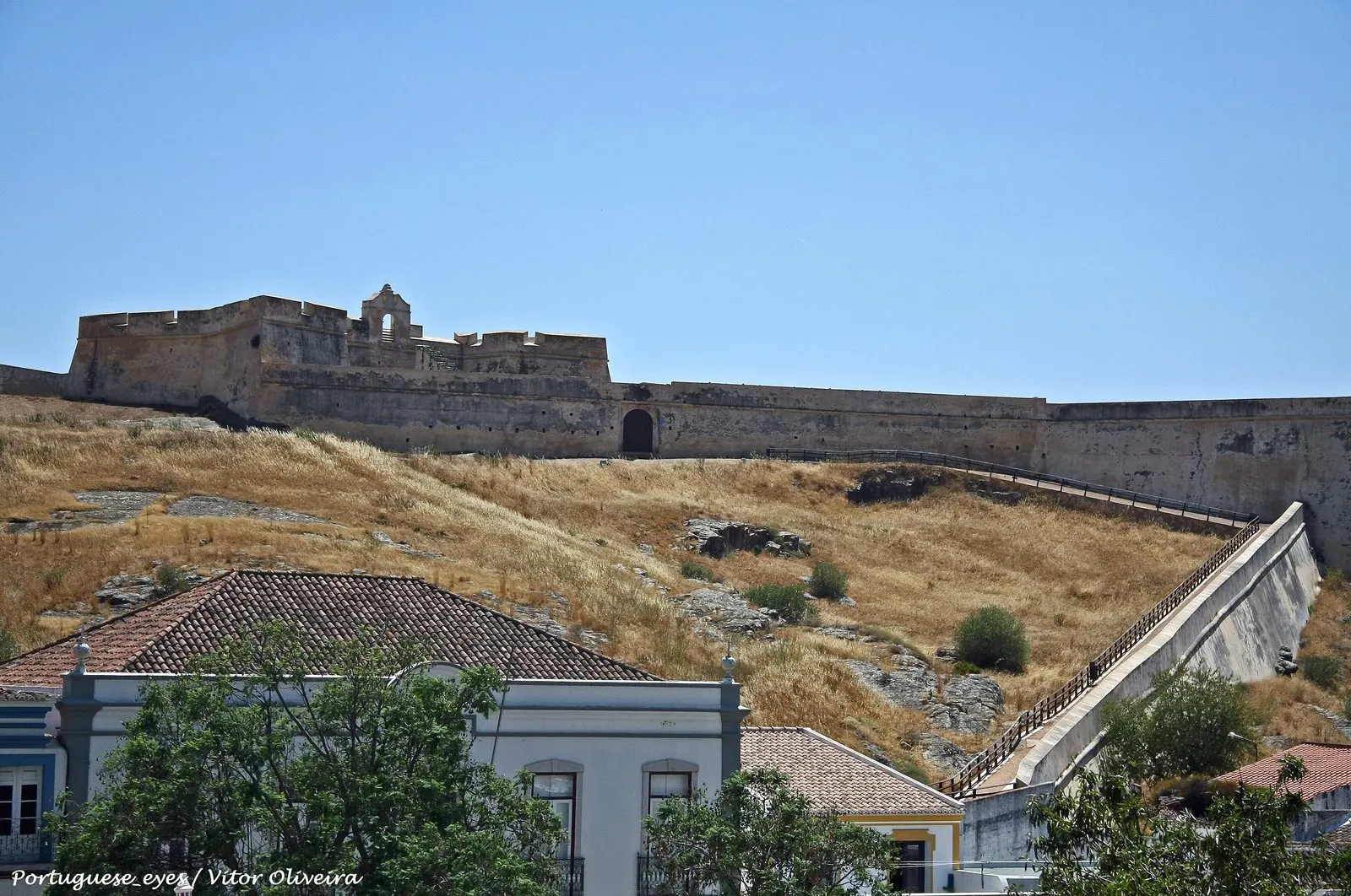
Forte de São Sebastião (Castro Marim): Restoration fortress started in 1641 by the Guadiana, across from Ayamonte, with a wall linking it to the castle.
- Location
- Castro Marim, Faro
- Built
- Iniciado em abril de 1641; cerca de ligação ao castelo a partir de 1660
In Castro Marim, the town at the southeastern tip of the Algarve, two hills rise. On one stands the medieval castle. On the other, to the south, stands the Forte de São Sebastião, a seventeenth-century bastioned fortification built during the Restoration War. From the top of its walls one can see the salt marsh, the Guadiana and, on the Spanish bank, the town of Ayamonte. The fort and the wall linking it to the castle made the town the most important fortified garrison in the Algarve.
A fort to protect the castle
Sixteenth-century plans of Castro Marim show the hill facing the castle, known as the cerro do Cabeço, as undeveloped. According to the catalogue the municipality published on the town, the Visitations of the Order of Santiago of 1565 already mention an unfinished hermitage dedicated to São Sebastião there. The hill was a danger: in case of siege, an enemy installed on the summit could batter the medieval walls at short range.
When the war with Spain began in 1640, the built-up area outside the walls was unprotected. Construction of the fort began in April 1641, a date recorded in the classification decree and which, according to the municipal catalogue, appears in the inscription over the entrance arch. The hermitage was absorbed into the new works. As compensation, King João IV ordered the present Church of São Sebastião, near the western entrance of the town. The inscription on the door, cited in the same catalogue, is explicit: the hermitage was built “because another was taken for a fort”, in the year 1650.
The classification decree describes the fort as a priority work in the national strategy for the southernmost section of the frontier. The plan is irregular and adapted to the hill. The decree and the catalogue count four half-bastions; the municipal webpage speaks of five bastions. The sources differ on this count. The main entrance faces north, towards the castle.
Not all contemporaries were impressed. In 1653, the French engineer Pierre de Saint Colombe, in Portuguese service, wrote that the fort “is not worth much”, its height being almost equal to its length. The catalogue attributes its weakness to a shortage of labour and resources on a secondary front of the war, far from the Alentejo and the Beira.
The seventeenth-century wall and the castle
An isolated fort was not enough. In October 1660, the governor of the Algarve, Martim Correia da Silva, wrote to the regent queen, D. Luísa de Gusmão, that work was already under way on a line to cover the suburb. The aim was to prevent the enemy from slipping in between the town and the fort. Thus the seventeenth-century wall came into being, with two stretches of curtain wall descending from the fort’s hill and climbing the castle’s hill.
The 2012 decree lists the elements that make up the monument: the Cortina de São Sebastião (São Sebastião curtain wall), the Baluarte de São Sebastião, the Baluarte do Enterreiro, the fort itself, the Baluarte Cheio, the Cortina das Lezírias, the Baluarte das Lezírias, the Cortina de Santo António, the Cortina do Forte, the powder magazine and the Revelim de Santo António. The first two bastions form a hornwork. The names of the Lezírias come from the neighbouring creek. Only through this connection to the medieval enclosure, the decree emphasises, was an effective protection zone created for the town.
The castle is a separate monument, classified on its own. On it, see the page on Castro Marim and the national network of castles.
Earthquake, wars and barracks
The earthquake of 1755 ruined the fort and the wall, which were repaired. According to the municipal catalogue, the War of the Oranges, in 1801, prompted a further remodelling, adapting the works to more modern firearms and raising the walls. Between 1819 and 1829, the fort served as barracks for the 4th Caçadores Battalion. To house it, the Cortina do Forte and casemates were built, enclosing an inner courtyard known as the Citadel of the Fort. From then on, only the citadel received maintenance, and the seventeenth-century wall was left to decay.
Inside, a small vaulted chapel, inherited from the hermitage, and the frame of the former bell gable can still be seen.
Restoration and classification
The fort and the wall were the subject of a programme of recovery and consolidation. The municipal catalogue publishes an aerial view taken after the works, dated 2007, and cites a final reconstruction report of 2008. According to the decree, the intervention restored the complex’s original volumes, profiles and levels.
The classification process was proposed by the Câmara de Castro Marim in 1986 and approved in 1997. Classification as a National Monument came with Decree No. 31-B/2012, published in the Diário da República, 1st series, No. 252 (supplement), on 31 December 2012. The official designation is lengthy: “Forte de São Sebastião and other surviving architectural elements of the bastions and ravelins that linked it to the castle”.
The special protection zone has not yet been established. According to the national register, a proposal for revision was published as a notice in 2022, but it was returned to the CCDR Algarve in April 2024 to complete the file. The complex falls within the castle’s protection zone. It is not part of any UNESCO listing.
Planning a visit
As of the consultation on 5 November 2026, the Municipality of Castro Marim webpage indicated that the fort may be visited by prior appointment, arranged by email. We found no regular opening hours or published prices. The exterior stretches of the wall and the bastions can be seen from the town’s streets. Please confirm the conditions with the Câmara before going.
To put the fort in context, compare it with the bastioned fortresses along the Alentejo border and with the castle of Alcoutim, upriver. The regional itinerary is at Algarve and the wider military history at fortifications.
Photograph by Vitor Oliveira, 2016. Original on Wikimedia Commons, under CC BY-SA 2.0; resized and compressed for the web, without altering the composition.
Frequently asked questions
- When was the Forte de São Sebastião built?
- Construction began in April 1641, at the start of the Restoration War, a date recorded by the classification decree and the municipality. The wall linking the fort to the castle was begun later, in 1660, according to the municipal catalogue on the fortress of Castro Marim.
- Why was it built on that hill?
- The hill, where a hermitage of São Sebastião once stood, dominated the medieval castle at short firing range. Occupying it with a fort prevented an enemy from using it to batter the walls and strengthened the defence of the Guadiana frontier, facing the Spanish town of Ayamonte.
- Is the fort classified?
- Yes. The Forte de São Sebastião and the surviving elements of the bastions and ravelins that linked it to the castle are a National Monument under Decree No. 31-B/2012 of 31 December. As of the consultation on 5 November 2026, the special protection zone had not yet been established by ordinance.
- Can the interior be visited?
- As of the consultation on 5 November 2026, the Municipality of Castro Marim's webpage stated that visits were available by prior appointment via email. We found no regular opening hours published for the fort.
Sources
- Património Cultural, I.P. — Forte de São Sebastião e demais elementos arquitetónicos que subsistem dos baluartes e revelins que o ligavam ao castelo (70936)
- Património Cultural, I.P. — Atlas do Património Classificado, Forte de São Sebastião (NINV 349)
- Diário da República — Decreto n.º 31-B/2012, de 31 de dezembro
- Município de Castro Marim — Forte de São Sebastião
- Município de Castro Marim / CEPHA-UAlg — Castro Marim, baluarte defensivo do Algarve (catálogo)
- Wikidata — Forte de São Sebastião de Castro Marim (Q10284064)
Keep exploring
Heritage nearby
More places to discover from here. Approximate straight-line distances, within 50 km.