Monuments
Santiago do Cacém Castle
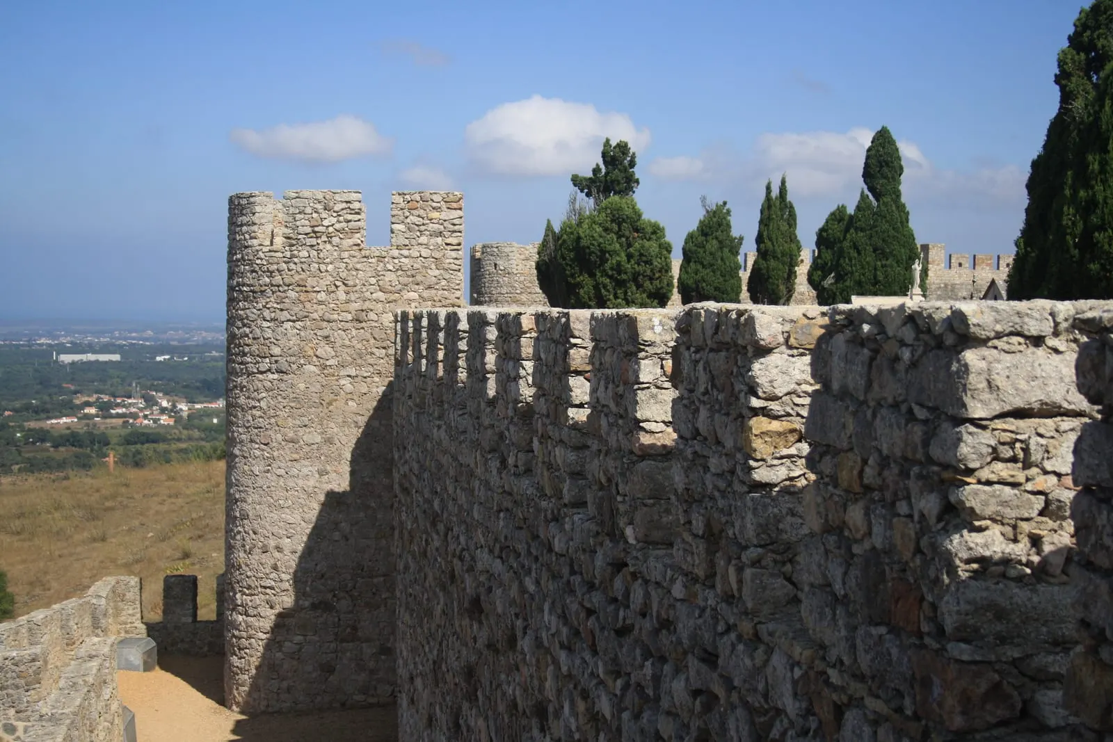
Santiago do Cacém Castle, an Islamic-origin Order of Santiago fortress with towers, a barbican and a former inner cemetery. National Monument since 1910.
- Location
- Santiago do Cacém, Setúbal
- Built
- Origem islâmica, anterior à conquista cristã de 1157–1158; alcaidaria dos séc. XIII–XIV
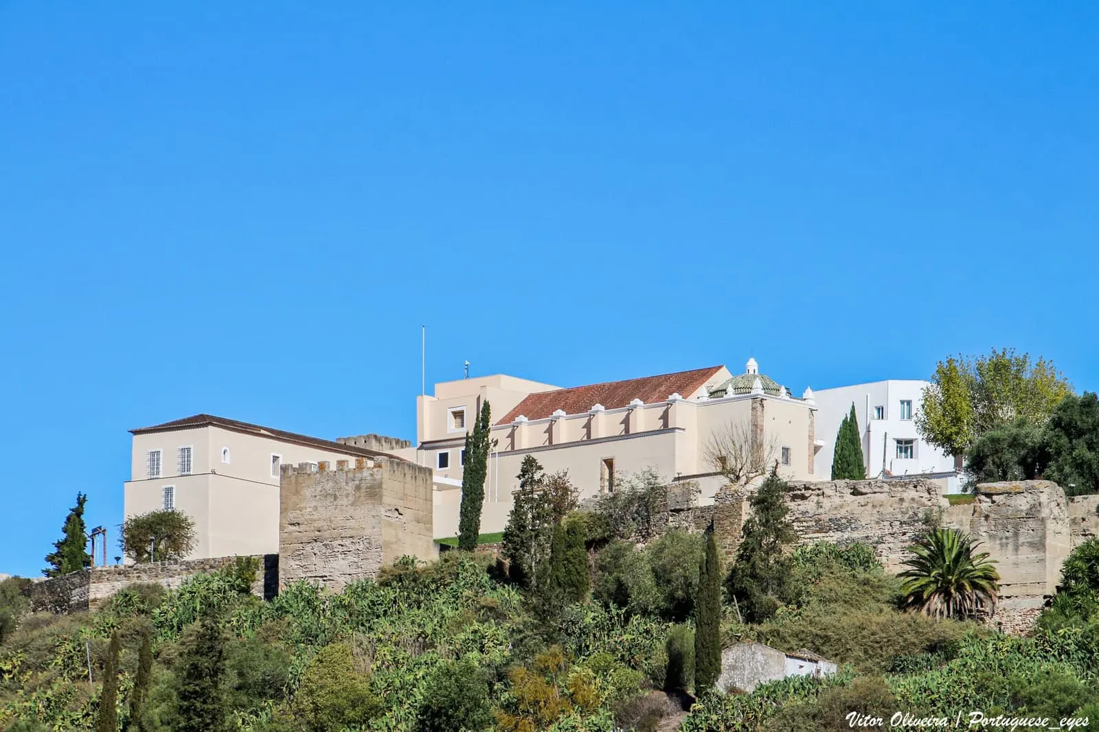
The Castle of Santiago do Cacém occupies the summit of the hill that dominates the town and the Alentejo coastal plain. According to the municipality, together with the Igreja Matriz, also a National Monument, it forms a monumental ensemble overlooking the historic centre. The fortress of Islamic origin passed to the Templars and then to the Order of Santiago, and ultimately served as a cemetery. It still preserves a circuit of walls with towers and an almost complete barbican.
From Cacém to Santiago do Cacém
The territory has been occupied since very early times. The Roman city of Miróbriga, on the neighbouring hill, is the best-known witness to this occupation. The national register of the Património Cultural, I.P. describes a decline from the 4th century and the arrival of the Muslims in 712. The name Cacém may derive from an Arab governor called Kassen. A local legend tells that a nobleman coming from the eastern Mediterranean killed Kassen, took the castle on Saint James’s day and named it Sant’Iago de Kassen. The register records the hypothesis and the legend without confirming either.
The Christian conquest is dated differently by the official sources. The national register speaks of its capture by the Templars in 1157, a loss in 1185 and recovery the following year by the Order of Santiago, which received the town by royal donation. The municipal tourism page dates the conquest to 1158, by D. Afonso Henriques with the Templar knights, and the donation to the Order of Santiago to 1186. The Almohads retook the stronghold in 1191, according to the register, or in 1190, according to the municipality. Definitive Christian possession came in 1217, under D. Afonso II, who confirmed the donation to the Order of Santiago. The name Santiago do Cacém derives from this link with the Order.
Lords of the castle
The national register notes that, more than a century after the conquest, the castle belonged to the princess D. Vetácia (the register’s spelling), a close associate of Queen Saint Isabel, and returned to the Order upon her death. The municipal page specifies that the town and castle were hers between 1310 and 1336, by exchange with the Master of the Order, and identifies her as the Byzantine princess D. Vataça Lascaris. According to the municipality, during the crisis of 1383–1385, the castle was among the Alentejo strongholds occupied by Castilian troops and recovered by D. Nuno Álvares Pereira. The national register adds the grant to the Dukes of Aveiro, in 1594, and the passage to the Crown in 1759, when the castle was already heavily damaged.
Ruin and cemetery
According to the municipality, the castle began to lose its defensive function at the start of the 16th century. By 1605 it was no longer inhabited and, by 1700, it was badly ruined. The Câmara chose the interior for the municipal cemetery in 1838; the national register places this use from the 19th century. The register also attributes part of the destruction of the walls to the construction of the Igreja Matriz in the 13th century. The municipal page notes that one of the towers was destroyed in 1796, when the parish church was rebuilt. The theme continues in historic cemeteries.
What can be seen
The castle has the form of a parallelogram. The national register gives it a length of 190 metres and ten towers and turrets, with loopholes, a wall-walk and a barbican preserved almost in its entirety. The municipal page counts nine towers and turrets, as it considers the tenth lost in 1796. Entry is through the only surviving gate. Above the gate, a heraldic group shows the cross of the Order of Santiago’s banner, the sword-cross and a shield with the five escutcheons of the kingdom. Inside lie the ruins of the former alcaidaria or alcázar, dating from the 13th–14th centuries and remodelled in the 15th–16th centuries. Within it survives a medieval tulha used to store grain.
Much of the present appearance results from restorations carried out from the 1930s by the Direção dos Serviços dos Monumentos Nacionais, according to the municipality.
Classification
The castle is a National Monument by the Decree of 16 June 1910, published in the Diário do Governo no. 136, of 23 June 1910. The decree calls it the “Castelo de São Tiago do Cacém”. The special protection zone, with a non aedificandi zone, is common to the castle and the Igreja Matriz. It was set by the Ordinance of 27 October 1949, published in the Diário do Governo, II Series, no. 265, of 15 November 1949. According to the Atlas do Património Classificado, the castle is under the remit of the Património Cultural, I.P. It is not part of any UNESCO inscription.
Planning the visit
The castle stands at the top of the historic centre, which extends down the eastern slope of the hill, with narrow, steep streets. When consulted on 5 November 2026, the municipal pages did not publish opening hours for the castle. The tourist information points page listed the Posto de Turismo de Santiago do Cacém, on the Praça do Mercado Municipal, open Monday to Friday from 8:30 to 16:30 and on Saturday from 9:00 to 15:00, closed on Sundays and public holidays (telephone 269 826 696). The same page listed a parish council office in the historic centre, but also showed a “closed” notice without making clear which of the offices it referred to; confirm by telephone. Check the conditions of access to the castle on the municipal tourism page before going.
The visit pairs well with Miróbriga. To compare with other castles of the Order of Santiago, see those of Alcácer do Sal, Palmela and Sesimbra. The regional context is in Alentejo and the national network in castles of Portugal.
Photograph by Koos van den Beukel, of 30 August 2017. Original on Wikimedia Commons, under CC0 1.0; resized and compressed for the web, without altering the composition.
Frequently asked questions
- What is the origin of the castle?
- The national register and the municipality attribute the first fortification to the Islamic period. The Christian conquest is dated 1157 by the national register and 1158 by the municipality; definitive Christian possession only came in 1217, under King Afonso II.
- Why was the castle used as a cemetery?
- After losing its military function, the enclosure fell into ruin. The national register notes the use of the interior as the village cemetery from the 19th century; the municipality states that the Câmara chose it as the municipal cemetery in 1838.
- Is the castle classified?
- Yes. It is a National Monument by the Decree of 16 June 1910, published in the Diário do Governo no. 136, of 23 June 1910. The special protection zone, shared with the Igreja Matriz, was set by ordinance of 27 October 1949.
- What is the relationship with Miróbriga?
- They are distinct sites. Miróbriga is the Roman city on the neighbouring Cumeada hill, classified separately; the castle crowns the hill of the present town of Santiago do Cacém.
Sources
- Património Cultural, I.P. — Castelo de Santiago do Cacém (70441)
- Património Cultural, I.P. — Atlas do Património Classificado, Castelo de Santiago do Cacém (NINV 4022)
- Diário do Governo — Decreto de 16 de junho de 1910 (n.º 136, 23-06-1910)
- Município de Santiago do Cacém, Turismo — Património Arquitetónico Militar
- Município de Santiago do Cacém, Turismo — Centros Históricos
- Município de Santiago do Cacém, Turismo — Postos de Informação Turística
- Wikidata — Castelo de Santiago do Cacém (Q5049824)
Keep exploring
Heritage nearby
More places to discover from here. Approximate straight-line distances, within 50 km.